
Oese (Basdahl)
|
Eyelet
Basdahl municipality
|
||
|---|---|---|
 |
||
| Height : | 14 m above sea level NHN | |
| Residents : | 322 | |
| Incorporation : | March 1, 1974 | |
| Postal code : | 27432 | |
| Primaries : | 04763, 04766 | |
Location of Oese in Lower Saxony |
||

Oese ( Low German Öös ) is next to Volkmarst a district of the municipality of Basdahl in the district of Rotenburg (Wümme) in Lower Saxony .
geography
Geographical location
The district of Oese is located in the east of the Basdahl community and borders the Gnarrenburg community . Oese is located about 6 km north of Gnarrenburg, about 1.5 km east of Basdahl, 3.5 km south of Barchel and about 4 km west of Fahrendorf (Gnarrenburg) and Klenkendorf . Oese is connected to the federal highway 74 via Basdahl and to the K102 via Osterwede and Fahrendorf.
Districts
The districts of Neu-Oese and Poggemühlen belong to Oese .
history
Oese is the former seat of the noble family von Issendorf . The seat is the "Gut Poggemühlen" with the manor house built in 1586.
Historical population development
| time | Residents |
|---|---|
| 1812 | 132 |
| 1848 | 137 |
| 1858 | 197 |
| 1910 | 178 |
| 1949 | 443 |
| 1961 | 359 |
| 1970 | 351 |
Culture and sights
religion
The patronage church “St. Christophorus Church ”, which was built in 1577 and 1578 by the knight Christoph von Issendorf from brick . Next to the church is the “Oese leisure and meeting place”, which is operated by the Bremervörde-Zeven parish.
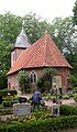
St. Christophorus Church

Leisure and meeting place in Oese


literature
- Bernhard Suin de Boutemand: Oeser Passions. The church in Oese reflected in the 600-year economic and social history of the villages of Basdahl, Oese and Poggenmühlen. 1975
- Martin Blanken, Diedrich Hildebrandt: Basdahl with Kluste, Oese, Poggemühlen and Volkmarst: the history of the villages, the farms and their families. Volksbank Gnarrenburg, 1984
Web links
Individual evidence
- ↑ http://www.basdahl.de/oese
- ^ Albrecht Friedrich Ludolph Lasius: The French Kayser State under the government of the Kayser Napoleon the Great, in 1812, Volume 1. Kißling 1813, Sied 103: http://books.google.de/books?id=Q_5OAAAAcAAJ&pg=PA103
- ↑ Friedrich W. Harseim, C. Schlüter: Statistical Manual for the Kingdom of Hanover. 1848, Sied 149: http://books.google.de/books?id=eOI-AAAAcAAJ&pg=PA149
- ^ Franz Heinrich Ungewitter: Latest description of the earth and history. 1858, Sied 420: http://books.google.de/books?id=ZkoNAQAAIAAJ&pg=PA420
- ^ Http://www.gemeindeververzeichnis.de/gem1900/gem1900.htm?hannover/bremervoerde.htm
- ^ New archive for Lower Saxony. Volume 3, W. Dorn, 1949, Sied 871