Oliveira (Mesão Frio)
| Oliveira | ||||||
|---|---|---|---|---|---|---|
|
||||||
| Basic data | ||||||
| Region : | Norte | |||||
| Sub-region : | Douro | |||||
| District : | Vila Real | |||||
| Concelho : | Mesão Frio | |||||
| Coordinates : | 41 ° 10 ′ N , 7 ° 50 ′ W | |||||
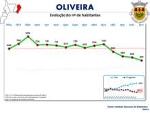
| Residents: | 391 (as of June 30, 2011) | |||||
| Surface: | 3.44 km² (as of January 1, 2010) | |||||
| Population density : | 114 inhabitants per km² | |||||
| Postal code : | 5040-215 | |||||
| politics | ||||||
| Mayor : | José Ângelo Pinto Vieira ( PS ) | |||||
| Address of the municipal administration: | Junta de Freguesia de Oliveira Lugar da Quelha 5040-215 Oliveira |
|||||
Oliveira is a village and a municipality in northern Portugal .
history
Traces of human presence go back at least to the Bronze Age and point to the later occasional settlement of local caves by Lusitans , who maintained a fortified settlement in nearby Cidadelhe . From the time of the following Roman rule from 134 BC. BC remains of a Roman road remained.
The current location was first documented in 970. Portugal's first King D. Afonso Henriques gave Oliveira to the Tarouca Monastery in 1170 . In the royal registers of 1289 Oliveira was listed as a parish of the Penaguião district. In the course of administrative reforms after the Miguelistenkrieg in 1834 Oliveira came to the Mesão Frio district.
administration
Oliveira is the seat of a municipality of the same name ( Freguesia ) in the district ( concelho ) of Mesão Frio in the Vila Real district . 391 inhabitants live in it on an area of 3 km² (as of June 30, 2011).
The following places belong to the municipality:
|
|
Web links
- Website of the Oliveira community at the Mesão Frio district administration
- Entry to Oliveira in the Mapas de Portugal
- Entry to Oliveira on www.mesaofrio.com.pt
Individual evidence
- ↑ a b www.ine.pt - indicator resident population by place of residence and sex; Decennial in the database of the Instituto Nacional de Estatística
- ↑ Overview of code assignments from Freguesias on epp.eurostat.ec.europa.eu
- ↑ Oliveira's profile and story at www.mesaofrio.com.pt, accessed December 9, 2018
- ↑ regis the parish church Igreja de Santa Maria (under Cronologia ), Portuguese monument list SIPA, accessed on December 9, 2018


