
Ord Bridge

The Ord Bridge is a pedestrian bridge across the Singapore River in Singapore . It crosses the river at Clarke Quay in the Singapore River Planning Area. The bridge is 41 meters long and 7 meters wide.
In 1865, the ABC Bridge , sometimes also called Ordnance Bridge ("Artillery Bridge"), was located on the site of today's Ord Bridge . It connected the River Valley Road with Magazine Road, where the British Army used to have an ammunition and weapons depot in Fort Canning . Except for a few plans from that time, such as the Map of Singapore Town from 1881, there are no written records of the bridge. Another traditional name is Toddy Bridge : " toddy shops" were taverns with coconut and palm wine that were available nearby.
The new Ord Bridge Bridge was built in 1886 to replace the demolished ABC Bridge. It consisted of a steel structure and was named after Sir Harry St. George Ord , the first governor of Straits Settlements (1867–1873), after they were given the status of Crown Colony in 1867 .
In 2008, the bridge was selected as part of the Urban Redevelopment Authority's expanded maintenance program.
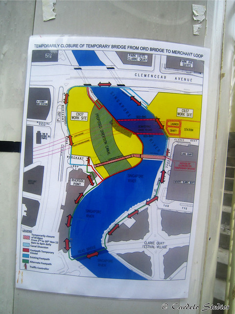
In the course of the construction of an underground station ( MRT station Fort Canning), a diversion channel had to be temporarily excavated near the Ord Bridge. To enable pedestrians to connect to the Merchant Loop and Merchant Road via this canal, a provisional bridge was built in 2012, which was called the Temporary Bridge for a longer period of time .
Individual evidence
- ↑ a b Lim Tin Seng: Bridging History: Passengers Across Water , Bridges of Colonial Times , Ord Bridge section , in: Biblioasia, Portal of the National Library Board, Singapore Government, online at: nlb.gov.sg/biblioasia / ...
- ↑ Victor R Savage, Brenda Yeoh: Singapore Street Names: A Study of Toponymics , Marshall Cavendish International Asia Pte Ltd, Singapore 2013, ISBN 978-981-4408-35-6 , keyword ... Bridge , pages ??? 65ff. , online at: ??? books.google.de / ...
- ↑ Bridges , Ord Bridge Section , Portal of the Ministry of Education of the Singapore Government, online (archived) at: web.archive.org / ...
- ^ Ord Bridge , keyword in Wan Meng Hao and Jacqueline Lau: Heritage Places of Singapore , Chapter West Bank, Marshall Cavendish International (Asia) Private Ltd., Singapore 2009, ISBN 978-981-261-858-0 , page 14, online - Edition on: books.google.de / ...
- ↑ Ord Bridge , website of the state's National Heritage Board, online at: roots.sg / ...
- ↑ Ord Bridge , short entry on the Emporis portal, online at: emporis.com / ...
- ↑ Bridges of Singapore River , private website "Singapore Lost & Filed", section ... Bridge , online at: lostnfiledsg.wordpress.com / ...
- ↑ Location of the Temporary Bridge, Ord Bridge and Merchant Road, online at: google.com / ...
- ↑ Sketch of the diversion channel and the temporary bridge, online at: arm4.staticflickr.com / ...
Web links
| Singapore River |
Alkaff | Anderson | Cavenagh | Clemenceau | Coleman | Elgin | Esplanade | Jiak Kim | Jubilee | Kim Seng | Ord | Pulau Saigon | Read | Robertson |
|---|---|
| Marina Reservoir |
Coordinates: 1 ° 17 ′ 27.3 " N , 103 ° 50 ′ 38.4" E