Singapore River
| Singapore River | ||
| Data | ||
| location | Singapore | |
| River system | Singapore River | |
| origin | Alexandra Canal at the Kim Seng Bridge 1 ° 17 ′ 32 ″ N , 103 ° 50 ′ 0 ″ E |
|
| muzzle | to Marina Bay Coordinates: 1 ° 17 ′ 17 " N , 103 ° 51 ′ 14" E 1 ° 17 ′ 17 " N , 103 ° 51 ′ 14" E
|
|
| length | 3.2 km | |
|
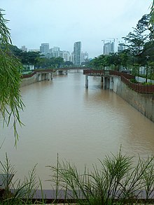
View from the OCBC Center on the Singapore River |
||
The Singapore River ( malai. Sungai Singapura , Chinese 新加坡 河 , Pinyin Xīnjiāpō Hé ) is a small river that makes its way through the urban area of Singapore and which is of great historical importance for the city. The Singapore River begins in the Central Area in the southern part of the city of Singapore and finally flows into Marina Bay , which forms the entrance to the Pacific Ocean . The upper catchment area of the river water is known as the Singapore River Planning Area , the northernmost part of the watershed is the River Valley. Almost all of the banks of the river belong to the city's central trading districts. It is one of a total of 90 rivers that exist in Singapore and the islands belonging to the city-state .
geography
The Singapore River is just 3.2 km in length today. Its current origin lies with the Kim Seng Bridge, from where it winds through the center of Singapore and flows into Marina Bay and thus into the Pacific. It is fed by the Alexandra Canal, which runs from Commonwealth Avenue . The former river sections include the Alexandra Canal, which emerges at the North Buona Vista Road , and the Sungei Ulu Pandan, which meets the Sungei Pandan . This in turn flows into the ocean at the level of the West Coast Park . The source of the two waterways (Alexandra Canal and Sungei Ulu Pandan ) is in the Queenstown area in the Ridout Road area and Tanglin Halt area near Margaret Drive . Together with these former river sections, it once had a total length of 11 km.
history
When Sir Stamford Raffles reached the Singapore River in January 1819 , he found the Orang Laut people here . He immediately began negotiations with the "Temenggung", a nobleman from Johor who had ruled the area up until then and who had led the group that had settled there since 1811. Raffles must have recognized the importance of the river as soon as it landed, as in the same year 1819 work began on draining the north bank for the construction of the government building. From 1822 a land reclamation project was started on the southern bank and retaining walls and stairs were built on the bank of the river.
The mouth of the Singapore River was originally the ancient port of Singapore , naturally bordered by the city-state's southern islands. Historically, the city of Singapore initially grew around this port, so that the river estuary advanced to a center of trade, commerce and finance early on. To this day, the area around the old mouth of the Singapore River, the Downtown Core , has remained the most expensive and economically important district in Singapore.
In the past it was mainly the Chinese who lived on the south bank , the Malays settled in Kampongs further upstream, and the Indians lived in the districts of Rochor, Kallang and Geylang until they were ousted by the Chinese.
In ancient times, the Singapore River was the colony's lifeline . It was the main artery of trade, the center of commerce, and the heart of the re- export trade . The river was once full of lighters , Bumboats (provisions boats), Tongkangs and sampans , while on its banks bullock carts hauled to and from the formerly rocky estuary. A civilization existed here long before that , which was finally conquered in 1376 by the Javanese Majapahit Empire and perished in the process. It can be assumed that the Malay prince who, according to legend, gave the city its name Singha Pura (Lion City) had to sail along here .
However, with the expansion of trade, traffic density increased. which also increased the pollution of the river. In addition, the bridges were built too low, either due to a lack of knowledge at the time or due to a lack of foresight, and the river was too shallow to serve as a waterway for expanding shipping. Nonetheless, the historic river that Raffles had once carved out of salty alluvial land , sandbars and mangrove swamps was at that time a testament to the British rule that shaped Singapore until 1962.
Pollution and cleaning
From 1880 onwards, the traffic density on the Singapore River increased due to the rapid expansion of trade, urbanization and economic activities of the Chinese, Malay and Indian ethnic groups. To the same extent, however, the water pollution increased through the introduction of rubbish, as well as the inflow of sewage and other by-products from the industrial companies located along the river. Other factors contributed to the pollution of the river and the Kallang Basin , such as waste from pig and duck farms, residues from street and vegetable wholesalers, and the existence of many commercial buildings without sewers. The transport, boat building and shipyards along the river also contributed to the pollution of the water. There were about 750 in 1977. Light , on the River Singapore and Kallang Basin were operated. The residues, heavy oils and sewage from these boats and barges also polluted the river.
That year, Lee Kuan Yew , the then Prime Minister of Singapore, advanced an ambitious plan entitled "The Clean-up of the Singapore River and Kallang Basin," which aimed to clean up the two main bodies of water and within ten years should allow the river to fish again.
In the fall of this year, government-initiated cleaning of the river finally began. The plan included, among other things, the development of the infrastructure , such as the construction of apartments, the construction of industrial workshops and the creation of sewers. In this context, the relocation of squatters , dealers and industrial companies was also massively promoted . The livestock farming, which until then had been carried out in the backyards, was also shifted away from the center and the transformation of the street trade into shopping centers was accelerated, which gradually led to a decline in the sources of pollution. The industrial companies located on the river were transferred to other locations and the squatters were quartered in apartments. Every day, masses of waste were incinerated while street vendors were given licenses and assigned specific areas with adequate sewer systems. The excavation of the river bed and the removal of hundreds of tons of debris that had piled up on the bottom of the Singapore River over the years finally helped the return of marine biology and ensured that the river could again be influenced by the tides.
In 1987, ten years after work began, the cleaning process for the Singapore River and the Kallang Basin was finally complete. In September 1987 the Ministry of the Environment celebrated the successful implementation of the project with other government bodies and representatives of the law with a "Clean Rivers Commemoration" . After this extensive clean-up, it is now possible to marvel at performances on the Wayang River that are performed on bumboats , variety shows on pontoons or even boat races. Thanks to these cleaning measures , motor boats , dragon boats as well as pedal boats and sampans can be seen on the water again today.
The Singapore River today
After its outflow into the ocean was contained, creating a new reservoir and thus a valuable source of fresh water for the small city-state , the river is now part of the Marina Reservoir. The dam itself is now known as the Marina Barrage .
The area where the original mouth of the river once ran into the Strait of Singapore was later expanded and modified through land reclamation . These projects also created the Marina Bay , into which the Singapore River flows today.
The port of Singapore is now located to the west of the island and takes up a large part of the south-western coast, with the passenger ships usually docking at the Singapore Cruise Center on the HarbourFront . Although river shipping no longer plays an important economic role, it has now developed into a tourist and aesthetic center of the city.

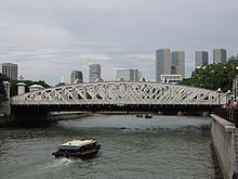
In the neighborhood and along the Singapore River you will find some temples , shrines and other places of worship that are well worth a visit. In addition, it characterize numerous crossings and bridges, such as the Anderson Bridge , the Elgin Bridge , the Cavenagh Bridge , as well as attractions like the Merlion , numerous shops and stores and hemming him big trees on which the banyan fig and Madras Thorn include . Some stretches of the river are defined by quays , such as Clarke Quay and Boat Quay , which are mainly used for trade and boat service. In 1860 three quarters of all boat trips were made from Boat Quay alone . In the neighborhood along the quays, shops and department stores flourished during the colonial times, and now bars and pubs , as well as restaurants and antique shops have moved into their buildings .
Individual evidence
- ↑ Singapore River Historical Overview ( Memento of the original from March 12, 2009 in the Internet Archive ) Info: The archive link was inserted automatically and has not yet been checked. Please check the original and archive link according to the instructions and then remove this notice.
- ↑ Article Alley ( page no longer available , search in web archives ) Info: The link was automatically marked as defective. Please check the link according to the instructions and then remove this notice.
- ↑ Marina Reservoir ( Memento of the original from April 5, 2016 in the Internet Archive ) Info: The archive link was inserted automatically and has not yet been checked. Please check the original and archive link according to the instructions and then remove this notice.


