Orhaneli Çayı
|
Orhaneli Çayı upper course: Kocaçay, Kocasu Deresi ancient names: Rhyndakos, Rhyndacus |
||
|
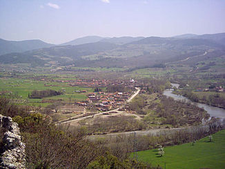
Orhaneli Çayı near Çaltılıbük |
||
| Data | ||
| location | Bursa , Kütahya ( Turkey ) | |
| River system | Simav Cayi | |
| Drain over | Adırnaz Çayı → Simav Çayı → Sea of Marmara | |
| Headwaters |
Murat Dağı 39 ° 3 ′ 22 ″ N , 29 ° 43 ′ 15 ″ E |
|
| muzzle |
Adırnaz Çayı coordinates: 39 ° 56 '38 " N , 28 ° 32' 7" E 39 ° 56 '38 " N , 28 ° 32' 7" E
|
|
| length | approx. 250 km | |
| Reservoirs flowed through |
Kayaboğazı Dam , Çınarcık Dam |
|
| Medium-sized cities | Tavşanlı | |
The Orhaneli Çayı is a right tributary of the Adırnaz Çayı in the provinces of Kütahya and Bursa in northwestern Turkey . The Orhaneli Çayı forms the upper reaches of the ancient river Rhyndakos (Latinized Rhyndacus ).
The Orhaneli Çayı rises in the Murat Dağı mountain range in the south of the Kütahya province. It initially flows as Kocaçay (also Kocasu Deresi ) in a northerly direction. It flows east past Çavdarhisar . Further north, the river is dammed by the Kayaboğazı Dam . Then it flows through the district town of Tavşanlı and now turns to the northwest and crosses the provincial border to Bursa. It flows north past the small town of Orhaneli . The Orhaneli Çayı is dammed a little later by the Çınarcık dam . Part of the water is diverted directly to a hydropower plant on Lake Uluabat Gölü . The Orhaneli Çayı now flows in a westerly direction and passes the town of Çaltılıbük , before finally meeting the Adırnaz Çayı (also Aliova Çayı ), which flows north, at the town of Camandar .
