
Uluabat Gölü
| Uluabat Gölü | |
|---|---|

|
|
| Geographical location | Bursa Province , Turkey |
| Tributaries | Mustafakemalpasa Cayi |
| Drain | Uluabat Deresi |
| Islands | 8th |
| Places on the shore | Several places like Akçapınar, Eskikaraağaç , Fadılı, Gölkıyı, Gölyazı , Uluabat |
| Data | |
| Coordinates | 40 ° 10 '31 " N , 28 ° 35' 29" E |
 |
|
| Altitude above sea level | 8 m |
| surface | 135 to 160 km² |
| length | 23 to 24 km |
| width | 12 km |
| Maximum depth | 10 m |
| Middle deep | 3 m |
| Catchment area | 10,500 km² |
The Uluabat Gölü , also Apolyont Gölü , is a body of water in the vastness of the province of Bursa in the Marmara region . The large lake covers an area of 135 to 160 km², depending on the water level, but is a shallow lake with an average depth of three meters. The roughly triangular lake has a west-east extension of 23-24 km and is 12 km long from north to south. The lake was created by tectonic subsidence in the region.
Geology and hydrology
The Uluabat Gölü is located together with the neighboring Manyas Gölü to the west in a geologically young tectonic depression zone, which is called the Manyas Uluabat Basin (MUB) or South Marmara Basin. This basin began to sink in from the late Miocene in connection with Alpine tectonics. At least the most recent phase of the basin development (late Pliocene to today) is unanimously attributed in the literature to the activity of the North Anatolian Fault Zone (NAFZ), a transform disorder with a dextral sense of movement that limits the Anatolian small plate to the north against the Eurasian plate . In contrast, the subsidence (subsidence) of the early basin phase (late Miocene to early Pliocene) is partially linked to an older fault system, the Thrace-Eskişehir fault zone (TEFZ). The thickness of the neogene sediments deposited by the rivers (fluviatil) and the lakes (lakustrin) , which make up the main part of the basin filling, is locally up to 400 m. Lacustrine sediments from the Quaternary period overlap the Neogene in an angular discordant manner as a result of an inversion phase in the early Pliocene and are only distributed in the pelvic center (i.e. in the MUB sensu stricto ).
There are eight islands in Uluabat Gölü, a ninth is a peninsula or an island depending on the water level. The largest island is Halilbey Island, which has a medieval fortification. The Mustafakemalpasa Cayi - a section of the ancient Rhyndakos - feeds the lake and flows into the Uluabat in the southwest. In addition, a small part of the water comes from precipitation and underground karst springs . The Uluabat Deresi , which emerges in the west of the lake and flows over the Susurluk Çayı into the Marmara Sea , acts as a drain .
According to measurements, the average annual rainfall is 650 mm with a minimum in August (10.6 mm) and a maximum in December (104.9 mm). Most of the water evaporates in August with 172.1 mm, while it is the least in March (1.2 mm). The pH value of the water varies between 7.45 and 10.60. The high pH value can be explained by the extensive limestone at the lake. The northern part of the lake is basic, while the water at the mouth of the Mustafakemalpasa Cayi is neutral.
Ecology and environmental protection
Most of the shore is lined with aquatic plants such as reeds , swamp zest , rushes and knot grass, and this is where the largest abundance of white water lilies in Turkey can be found. Since the Uluabat lies on a migration route of migratory birds, there are rich occurrences of different, partly endangered bird species. In 1996, around 430,000 birds were counted, making the lake an important bird breeding area. The birds that breed here include the pygmy pinto , bog duck , whitebeard tern and the Dalmatian pelican . According to a count of the Turkish Environmental Protection Society DHKD (Doğal Hayatı Koruma Derneği) In 1998, bred by the lake 823 couples Pygmy, 105 pairs night heron , 109 pairs Rallenreiher and 48 pairs Löffler . In the lake there are 21 different types of fish such as carp , rudd , pike , catfish and eel. There are also a number of mammals such as badgers, otters , brown-breasted hedgehogs , golden jackals , martens, wild boars , weasels and house shrews. The fauna is rounded off by amphibians and reptiles.
Uluabat Gölü has been part of the Ramsar Convention for the Protection of Wetlands since 1998 .
At the entrance to Mustafakemalpasa Cayi, a large delta with small islands on which reeds and willows grow has formed due to the floating debris. Parts of this fertile soil were cut off, drained and made usable for agriculture and animal husbandry.
The river is heavily polluted and, despite Ramsar joining a few years ago, no progress has been made in this regard. Due to the industrialization of the nearby cities, sewage from z. B. Tanneries and canning factories across Mustafakemalpasa Cayi into the lake.
Settlement and History
Traces of settlement on the lake go back to 1200 BC. BC back. The lake was part of the Bithynian landscape . The classic Greek name Apolloniatis ( Απολλωνιάτις ) was derived from the town of Apollonia ad Rhyndacum (now the village of Gölyazı ) on the northeastern shore of the lake. The region was known for keeping silkworms for centuries. With the advent of synthetic fibers, this industry died out. The main source of income for today's 17 villages around the lake is fishing. North of the lake is the D200 expressway from Bursa to Çanakkale . Major cities nearby are Mustafakemalpaşa and Karacabey .
The old Apollonia ad Rhyndacum was on a peninsula in the northeast corner of the lake. Ancient and medieval remains of the city are known today as Taş Kapı (remains of the castle) and Deliktaş (probably remains of an aqueduct), and there are also ruins of a theater. On the island of Kız Adası to the west of the village there are the remains of a temple of Apollo . The Hagios Georgios Church dates from the 19th century, replacing the old destroyed church of the same name. The city's originally Greek population was mixed with Turks during the Ottoman Empire from the 14th century. After the First World War , as part of the population exchange between Greece and Turkey, the last Greeks were expelled and Turkish immigrants from Thessaloniki settled in their place . A mosque and a hammam of unknown age bear witness to the Ottoman period .
On the second largest, now uninhabited island of Manastır Adası, there has been the monastery of St. Konstantin (Hagios Konstantinos) since the time of the Byzantine Empire , of which ruins can still be seen today. The plant was operated until modern times. The founding date of the monastery is unknown because large parts of the monastery were replaced during an extensive restoration at the end of the 18th and beginning of the 19th century. It has been known under the name of St. Constantine since the 16th century. Reports and tales from the 9th century about a monastery on the lake could refer to St. Constantine, but according to Cyril Mango they are not reliable. The monastery is essentially a cross-domed church , but in contrast to the typical Byzantine churches of the time, it has two apses facing east and west.
Other classic names for the lake were Lacus Apolloniatis and Lake Artynia .
gallery

The lake as seen from Gölyazı

Another view of the lake
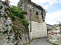
Ancient remains in Gölyazı / Apollonia

Roundabout in the center of Karacabey


Web links
- Ali Mehmet Celâl Şengör et al .: The north anatolian fault: A new look , published in Annual Review of Earth and Planetary Sciences , Vol. 33 (2005), pp. 37–112 doi: 10.1146 / annurev.earth.32.101802.120415 (English)
- Bahar Suseven: The Situation of the Eurasian Fishotter (Lutra lutra) at Lake Uluabat , (2005, English)
- Cenk Yaltırak: Tectonic evolution of the Marmara Sea and its surroundings , published in Marine Geology 190 (2002), pp. 493-529, doi: 10.1016 / S0025-3227 (02) 00360-2 (English)
- Cyril Mango : The Monastery of St. Constantine on Lake Apolyont , published in Dumbarton Oaks Papers , Vol. 33 (1979), pp. 329–333 (English)
- Güray Salihoğlu and Feza Karaer: Uluabat gölü için ekolojik risk değerlendirmesi (Ecological risk assessment for lake Uluabat) , published in itü dergisi / e 15 (2005), No. 1–3, pp. 17–28 (Turkish)
- Hüseyin Turoğlu and İsa Cürebal: Karaburun (İstanbul) ve Uluabat (Bursa) yalıtaşları , published in Coğrafya Dergisi 13, İstanbul (2005), pp. 57-66 (Turkish)
- Naci Görür et al .: Origin of the Sea of Marmara as Deduced from Neogene to Quaternary Paleogeographic Evolution of its Frame , published in International Geology Review , Vol. 39 (1997) No. 4, pp. 342-352 doi: 10.1080 / 00206819709465276 (English)
- Serdar Aybek and Ali K. Öz: Preliminary Report of the Archaeological Survey at Apollonia ad Rhyndacum in Mysia. , published in Anadolu / Anatolia 27 (2004) pp. 1–25 doi : 10.1501 / Andl_0000000312 (English)
- Türkiye'nin Ramsar Alanları Değerlendirme Raporu , 2008 Report on the Status of Waters Part of the Ramsar Convention (Turkish)
- Uluabat hayata dönüyor , article in the Radikal of June 16, 2004 (Turkish)
Individual evidence
- ↑ Ali Mehmet Celâl Şengör et al.
- ^ Ali Mehmet Celâl Şengör et al .; Cenk Yaltırak
- ↑ Cenk Yaltırak
- ↑ Cenk Yaltırak; Naci Görür et al.
- ↑ Turoğlu & Cürebal, p 63
- ↑ Bahar Suseven, p 54
- ↑ Bahar Suseven, p 55
- ^ Ramsar List . Ramsar.org. Retrieved February 8, 2014.
- ↑ Bahar Suseven, p.9
- ↑ Bahar Suseven, p.7
- ↑ Aybek & Öz, p. 3
- ↑ Aybek & Öz, p. 6
- ↑ Cyril Mango, p. 332
- ↑ Cyril Mango, p. 332
- ↑ Cyril Mango, p. 333