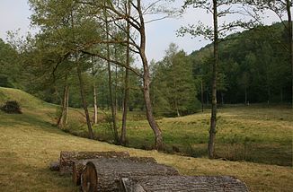
Ottersbach (victory)
|
Ottersbach Halfterbach |
||
|
The Ottersbach near Mittelottersbach |
||
| Data | ||
| Water code | DE : 272578 | |
| location | North Rhine-Westphalia , Germany | |
| River system | Rhine | |
| Drain over | Victory → Rhine → North Sea | |
| source | Southeast of Bornscheid 50 ° 49 ′ 1 ″ N , 7 ° 27 ′ 47 ″ E |
|
| Source height | 250 m above sea level NHN | |
| muzzle | At Eitorf -Halft in Sieg Coordinates: 50 ° 46 ′ 16 ″ N , 7 ° 28 ′ 42 ″ E 50 ° 46 ′ 16 ″ N , 7 ° 28 ′ 42 ″ E |
|
| Mouth height | 85 m above sea level NHN | |
| Height difference | 165 m | |
| Bottom slope | 24 ‰ | |
| length | 6.8 km | |
| Catchment area | 11.533 km² | |
|
The Ottersbach near Niederottersbach |
||
The Ottersbach is a 6.8 km long, orographically right or northern tributary of the Sieg . It flows through the Ottersbach valley named after him .
course
The Ottersbach rises in a wooded area north of Eitorf - Rankenhohn . Its direction is initially southeast. After crossing under Landesstraße 317 , it flows around Rankenhohn and Eitorf-Kreisfeld from the east. South of Kreisfeld it is fed by the Methbach and the Uländerbach . The Honsbach flows into it near the villages of Eitorf-Oberottersbach and Mittelottersbach . The Ottersbach now changes its course in a more southerly direction. At Niederottersbach it is reinforced by the Rieferather Bach coming from the left . Thereafter, the Ottersbach is also called Halfterbach . Between Niederottersbach and Köttingen, it forms the Eitorf- Windeck municipal boundary . It flows through Eitorf-Köttingen and finally flows into the Sieg at Eitorf-Halft.
Tributaries
The most important tributary of the Otterbach is the 4.5 km long Rieferather Bach . Its catchment area of 4,324 km² corresponds to about 37% of the Ottersbach. The tributaries that are named according to the German basemap are named below. The streams that are not recorded in the NRW water directory are named without a water code number.
| Surname |
Position [km] |
location | Length [km] |
Catchment area [km²] |
Mouth height [m. ü. NHN] |
DGKZ |
|---|---|---|---|---|---|---|
| Fengelbach | 6.206 | right | 0.5 | 201 | ||
| Ülander Bach | 5.795 | right | 0.7 | 158 | ||
| Methbach | 5.068 | right | 0.7 | 163 | ||
| Euelsbach | 4.834 | Left | 1.4 | 158 | 272578 12 | |
| Gehölzbach | 4.097 | Left | 0.3 | 142 | ||
| Honsbach | 4.075 | right | 0.7 | 142 | ||
| Rieferather Bach | 2,799 | Left | 4.5 | 4,324 | 118 | 272578 2 |
| Wilbertzhohner Bach | 2,680 | right | 1.2 | 117 | 272578 92 | |
| Eichenbach | 2.263 | right | 0.4 | 111 | ||
| Talbach | 2.180 | Left | 0.7 | 109 | ||
| Spröttbach | 1,795 | right | 0.8 | 106 | ||
| Kehlenbacher Bach | 1.488 | Left | 1.0 | 103 | 272578 94 | |
| Kopfbach | 1.327 | right | 0.3 | 101 |
Individual evidence
- ↑ a b German basic map 1: 5000
- ↑ a b c d e f g Water directory of the State Office for Nature, Environment and Consumer Protection NRW 2010 (XLS; 4.67 MB) ( Notes )
- ↑ Topographical Information Management, Cologne District Government, Department GEObasis NRW ( Notes )
- ↑ a b c d e f g h i j k l m n o p q r s t u v Measurement based on the German base map 1: 5000

