Pará de Minas
| Município de Pará de Minas Pará de Minas |
|||
|---|---|---|---|
|
Aerial view of Pará de Minas
|
|||
|
|
|||
| Coordinates | 19 ° 52 ′ S , 44 ° 36 ′ W | ||
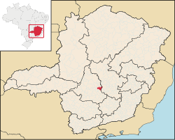
 Location of the municipality in the state of Minas Gerais Location of the municipality in the state of Minas Gerais
|
|||
| Symbols | |||
|
|||
| founding | 9th October 1848 (age 171) | ||
| Basic data | |||
| Country | Brazil | ||
| State | Minas Gerais | ||
| ISO 3166-2 | BR-MG | ||
| structure | 6 district | ||
| height | 788 m | ||
| climate | tropical, cwa | ||
| surface | 551.2 km² | ||
| Residents | 84,215 (2010) | ||
| density | 152.8 Ew. / km² | ||
| estimate | 93,969 (July 1, 2019) | ||
| Parish code | IBGE : 3147105 | ||
| Post Code | 35660-000 to 35665-999 | ||
| Telephone code | (+55) 37 | ||
| Time zone | UTC −3 | ||
| Website | parademinas.mg (Brazilian Portuguese) | ||
| politics | |||
| City Prefect | Elias Diniz (2019-2020) | ||
| Culture | |||
| Patron saint | Mater Dolorosa (as Nossa Senhora da Piedade) | ||
| economy | |||
| GDP | 2,744,669 thousand R $ 29,596 R $ per person (2017) |
||
| HDI | 0.725 (high) (2010) | ||
Pará de Minas , officially Portuguese Município de Pará de Minas , is a Brazilian municipality (Munizip) in the state of Minas Gerais . It is part of the metropolitan belt of the metropolitan region of Belo Horizonte and is located about 84 kilometers from Belo Horizonte . The population was estimated on July 1, 2019 at 93,969 inhabitants, who are called Pará-Minenses ( pará-minenses ) and live on a community area of around 551 km².
geography
Surrounding communities are Onça de Pitangui , São José da Varginha , Esmeraldas , Florestal , Mateus Leme , Itaúna , Igaratinga and Conceição do Pará .
The biome is composed of Brazilian Cerrado and Mata Atlântica .
history
The founding of Pará de Minas is closely linked to the migration of explorers and adventurers of the Brazilian gold rush, who searched for gold and precious stones in the area in the 1690s.
Many 18th-century Brazilian gold prospectors from what is now the São Paulo region established settlements near Pitangui , a nearby town on the Rio Paraopeba , the Rio São João and the Rio Pará river basin in Minas Gerais. The opening of gold mines in the Pitangui region brought many people and wealth to the region in the 18th century.
Among the many adventurers was a Portuguese named Manuel Batista, who established his residence in the Pará de Minas land. Batista, also known as Pato Fofo (or chubby duck), built a chapel next to his farm. The place became known as Patafufos Settlement and the chapel was raised to parish status under the control of Pitangui in April 1846. In 1848 the settlement was raised to city status.
The city status was revoked in 1850 because the locals did not meet all the conditions set out in the law of their emancipation. On June 8, 1858, the settlement was raised again to the status of a city and was given the name Vila do Pará. The solemn emancipation ceremony took place on September 20, 1859, the date the city was founded.
On July 15, 1872, the city was re-incorporated into the Pitangui community. The city regained its political autonomy in December 1874 when the Pará municipality was established.
Web links
- City Prefecture website , Prefeitura Municipal (Brazilian Portuguese)
- City Council website , Câmara Municipal (Brazilian Portuguese)
Individual evidence
- ↑ a b c Pará de Minas - Panorama. IGBE , accessed July 18, 2020 (Brazilian Portuguese).


