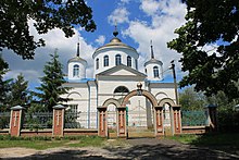
Parkhomivka (Krasnokutsk)
| Parkhomivka (Krasnokutsk) | ||
| Пархомівка | ||

|
|
|
| Basic data | ||
|---|---|---|
| Oblast : | Kharkiv Oblast | |
| Rajon : | Krasnokutsk Raion | |
| Height : | 122 m | |
| Area : | 10.716 km² | |
| Residents : | 3,286 (2012) | |
| Population density : | 307 inhabitants per km² | |
| Postcodes : | 62015 | |
| Area code : | +380 5756 | |
| Geographic location : | 50 ° 7 ' N , 35 ° 0' E | |
| KOATUU : | 6323585501 | |
| Administrative structure : | 2 villages, 2 settlements | |
| Address: | вул. Радянська 1 62014 с. Пархомівка |
|
| Website : | Local website | |
| Statistical information | ||
|
|
||
Parchomiwka ( Ukrainian Пархомівка ; Russian Пархомовка Parchomowka ) is a village in the northwest of the Ukrainian Oblast Kharkiv with about 3,300 inhabitants (2012).
The village, first mentioned in writing in 1688, is the administrative center of the 108.592 km² district council of the same name in the west of Krasnokutsk Raion , to which the village of Harkavets ( Гаркавець , ⊙ ) with about 10 inhabitants and the settlements Pawlivka ( Павлівка , ⊙ ) with about 270 Inhabitants and Stepowe ( Степове , ⊙ ) with about 200 inhabitants.
The village lies on the border with the oblasts Sumy and Poltava on the banks of Kotelva ( Котельва ), a 31-km long left tributary of Vorskla 14 km northwest of Rajonzentrum Krasnokutsk and about 100 km west of the Oblastzentrum Kharkiv .
Web links
- Municipal Council website (Ukrainian)
Individual evidence
- ↑ local website, general data ; accessed on October 30, 2017 (Ukrainian)
- ^ Local history of Parchomiwka in the history of the towns and villages of the Ukrainian SSR ; accessed on October 30, 2017 (Ukrainian)
- ^ Website of the district council on the official website of the Verkhovna Rada ; accessed on October 30, 2017 (Ukrainian)


