
Parzinnspitze
| Parzinnspitze | ||
|---|---|---|
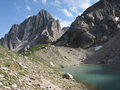
 Parzinnspitze with the Gufelsee in front of it |
||
| height | 2613 m above sea level A. | |
| location | Tyrol , Austria | |
| Mountains | Lechtal Alps | |
| Dominance | 0.6 km → Steinkarspitze | |
| Notch height | 101 m ↓ Scharte to the Steinkarspitze | |
| Coordinates | 47 ° 14 '21 " N , 10 ° 34' 33" E | |
|
||
| rock | Main dolomite | |
| First ascent | 1896 | |

The Parzinnspitze is a 2,613 meter high rocky peak in the Lechtal Alps in the Austrian state of Tyrol .
Location and surroundings
The Parzinnspitze is located on the western edge of the Parzinn , a high cirque located at 2,000 meters in the central Lechtal Alps. The entire border of the Parzinn consists of the Plattigspitzen (2,558 m) and the Kogelseespitze (2,647 m) in the west , which is connected to the Parzinnspitze (2,613 m) further south via the Gufelseejoch (2,281 m). The border continues to the southeast with the Schneekarlespitze (2,641 m), the Dremelspitze , which forms the southern end of the Parzinn, and the Schlenkerspitze (2,827 m) to the east .
Immediately south of the Parzinnspitze are the two Parzinntürme and the Steinkarspitze (2,650 m), which surround the Steinkar, located west of the Parzinnspitze.
In the immediate vicinity of the Parzinnspitze there are three lakes, including the two Parzinnseen and the Gufelsee . This lies between Parzinnspitze and Kogelseespitze immediately west of the Gufelseejoch.
Ascent
The starting point for climbing the summit is the Parzinnscharte (2,504 m) between the Parzinnspitze and the Parzinn towers located to the south of it. The difficulty is in the second degree (UIAA) and therefore requires not only a head for heights and surefootedness but also a certain level of climbing ability.
The easiest way to get to the Parzinnscharte is from the north, from the Gufelseejoch. This, in turn, can be reached both from the west (from Gramais via the brandy floor) and from the east (from the Hanauer hut via the Parzinnalm).
Literature and maps
- Dieter Seibert: Alpine Club Guide Lechtaler Alpen , Bergverlag Rother, Munich 2008, ISBN 978-3-7633-1268-9
- Alpine club map 1: 25,000, sheet 3/3, Lechtal Alps, Parseierspitze
For the representation of the area immediately east of the Parzinnspitze (Parzinn with Hanauer Hütte) it is also recommended:
- Alpine Club map 1: 25,000, sheet 3/4, Heiterwand and Muttekopf area
photos
View from Parzinnsee (cut right) to the south to Parzinnspitze (left half of the picture)
