
Dremel tip
| Dremel tip | ||
|---|---|---|
 Dremelspitze from the north |
||
| height | 2733 m above sea level A. | |
| location | Tyrol , Austria | |
| Mountains | Lechtal Alps | |
| Dominance | 1.3 km → Kleine Schlenkerspitze | |
| Notch height | 303 m ↓ Großkarscharte | |
| Coordinates | 47 ° 14 ′ 0 ″ N , 10 ° 36 ′ 0 ″ E | |
|
||
| rock | Main dolomite | |
| First ascent | 1896 by Otto Ampferer and Wilhelm Hammer | |
| Normal way | from the Vorderen Dremelscharte through the southern flank | |

The Dremelspitze is a 2733 m above sea level. A. high mountain in the Parzinn group of the Lechtal Alps in the Austrian state of Tyrol . The Dremelspitze has a large geographical dominance due to its 400 meter high rock walls made of main dolomite , which makes it a popular panoramic mountain for tours from the nearby huts. The Austrian alpinists and geologists Otto Ampferer and Wilhelm Hammer from the Academic Alpine Club Innsbruck made the first ascent of the mountain in 1896.
Location and surroundings
The tip is about six kilometers as the crow flies northwest of Starkenbach near Schönwies . Neighboring peaks in the northeast are the Große Schlenkerspitze (also called Großer Schlenker ) with 2827 meters height, in the east, separated by the Hintere Dremelscharte (2470 m), the Hanauer Spitze with 2553 meters, in the southeast, separated by the Verborgene Gratscharte (2520 m ) the Bergwerkskopf (2728 m) and in the west, separated by the Vordere Dremelscharte (2434 m), the Schneekarlespitze with an altitude of 2641 meters. South below the Dremelspitze lies the Steinsee at an altitude of 2222 meters .
Bases and tours
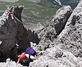
The Steinseehütte is located southwest of the Dremelspitze at 2061 meters above sea level . To the north is the Hanauer Hütte (1922 m). The mountain can be climbed from both huts in two and a half to three hours. From the Hanauer Hütte the path leads in a south-westerly direction, from the Steinseehütte in a north-easterly direction to the Vorderen (western) Dremelscharte (2434 m). The climbing route begins here, first over rubble and crumbling crags through the southern flank ( risk of falling rocks ), then over solid rock to the summit. The route is marked, but not secured at any point, and, according to literature, offers moderately difficult climbing at UIAA II difficulty in places .
- Dremelspitze, normal ascent

In the lower part

In the middle part
View of Steinsee and Steinseehütte

In the upper part, on the descent


Literature and map
- Dieter Seibert: Alpine Club Guide Lechtaler Alpen , Bergverlag Rother , Munich 2008, ISBN 978-3-7633-1268-9
- Alpine club map 1: 25,000, sheet 3/4, Lechtal Alps, Heiterwand and Muttekopf area