Pengjia Yu
| Pengjia Yu | ||
|---|---|---|
| View of the island | ||
| Waters | East China Sea | |
| Geographical location | 25 ° 37 '46 " N , 122 ° 4' 35" E | |
|
|
||
| surface | 1.141 3 km² | |
| Highest elevation | 165 m | |
| Residents | 40 35 inhabitants / km² |
|
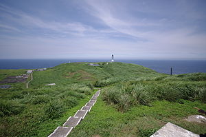
Pengjia Yu ( Chinese 彭佳 嶼 , Pinyin Péngjiā Yǔ , Pe̍h-ōe-jī Phêⁿ-ka-sū - "Pengjia Island"), or simply Pengjia , is a small island about 56 kilometers north of the island of Taiwan , by the Republic of China in Taiwan (ROC). The island is the furthest northerly territory under the control of the ROC. Administratively, it belongs to the Zhongzheng District of Keelung . The island may only be entered with special permission. On older maps it is recorded under the name Agincourt .
Surname
The current Chinese name is Pengjia . In the past, British nautical charts made the island known under the name Agincourt Island (after the battle site of the Hundred Years War ). At the time of the Japanese rule over Taiwan (1895-1945) the island was named Hōka-sho ( Japanese 彭佳 嶼 ), the Japanese pronunciation of the Chinese name.
description
The island is of volcanic origin . The last volcanic eruptions probably took place in the late Pleistocene to early Holocene . The coast has been severely eroded by waves over time and is very rugged. The current island area covers 1.1413 km² (114.13 ha ) and the highest point is 165 meters above sea level. The island vegetation consists predominantly of grassland with only a few isolated trees.
history
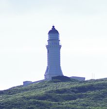
The island was probably first settled at least temporarily in the late phase of the Qing dynasty (1644–1911). Under Japanese rule, a 26.2 meter high lighthouse was built on Pengjia Yu, which went into operation on September 20, 1909 and is still in service today. The beacon is visible about 25 nautical miles . On January 9 and 11, 1945, and on May 15 and 16, 1945, the lighthouse was damaged by American bombing and reconstructed after the war.
The tower is also known by the name Pangchia Yu Lighthouse (in another transcription of the island's name). In May 2015 it was officially given the status of a “building of historic importance”.
present
Next to the lighthouse there is a weather station of the Taiwanese Meteorological Service and coastal protection facilities on the island. The island is currently inhabited by 40 people who provide services in these facilities.
About 76 nautical miles east of the island are the Senkaku Islands (in Japanese reading), or Diaoyutai Islands but, (in Chinese reading), which are under Japanese control by both the Republic of China, and from the People's Republic of China claimed . In the past there have been repeated tensions and incidents in the sea area of these islands, for example between mainland Chinese or (less often) Taiwanese fishing boats and the Japanese coast guard. In order to underpin its own presence in this sea area, Pengjia Yu was repeatedly visited by high-ranking Taiwanese politicians. President Ma Ying-jeou stayed here briefly on April 9, 2016 , after he had previously done so on September 7, 2012. On August 10, 2005, his predecessor Chen Shui-bian also visited the island.
climate
The climate is subtropical warm and rich in precipitation. The average temperature is 21.9 ° C and the annual rainfall is 1954 mm. The months of June to August are the least rainy, although the seasonal periods of rainfall are not as pronounced as on the island of Taiwan.
| Pengjia Yu | ||||||||||||||||||||||||||||||||||||||||||||||||
|---|---|---|---|---|---|---|---|---|---|---|---|---|---|---|---|---|---|---|---|---|---|---|---|---|---|---|---|---|---|---|---|---|---|---|---|---|---|---|---|---|---|---|---|---|---|---|---|---|
| Climate diagram | ||||||||||||||||||||||||||||||||||||||||||||||||
| ||||||||||||||||||||||||||||||||||||||||||||||||
|
Climate data from the years 1981–2010
Source: Taiwan Central Weather Bureau
|
||||||||||||||||||||||||||||||||||||||||||||||||||||||||||||||||||||||||||||||||||||||||||||||||||||||||||||||||||||||||||||||||||||||||||||||||||||||
Individual evidence
- ^ Zhongzheng District. Keelung City Government, accessed December 5, 2017 .
- ↑ a b c Jer-Haur Li, Wen-Liang Chiou: Changes in the Flora on Islet Pengchiayu across 100 Years . In: Taiwania . tape 51 , no. 3 , September 2006, p. 195–209 , doi : 10.6165 / tai.2006.51 (3) .195 (English, online [PDF]).
- ↑ a b Cindy Chang: Taiwan's Northern Stepping Stones. Taiwan Today, April 1, 2013, accessed December 5, 2017 .
- ^ Light House Cyclopedia. (No longer available online.) Tyjh.matsu.edu.tw, archived from the original on March 4, 2016 ; accessed on December 5, 2017 . Info: The archive link was inserted automatically and has not yet been checked. Please check the original and archive link according to the instructions and then remove this notice.
- ↑ Pengjia Islet lighthouse designated as historic site. Focus Taiwan, December 5, 2015, accessed December 5, 2017 .
- ↑ President visits Pengjia Islet to aver sovereignty. Taipei Times, April 10, 2016, accessed December 5, 2017 .
- ↑ 陳水扁 巡視 最 北 島嶼 宣示 釣魚台 主權 ("Chen Shui-bian pays a visit to the northernmost island to substantiate his claim to the Diaoyutai Islands"). BBC Chinese.com, August 10, 2005, accessed December 6, 2017 (Chinese).


