Pequeño Alpamayo
| Pequeño Alpamayo | ||
|---|---|---|
|
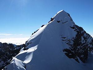
Pequeño Alpamayo as seen from the top of Cerro Tarija. |
||
| height | 5370 m | |
| location | La Paz Department , Bolivia | |
| Mountains | Cordillera Real , Andes | |
| Dominance | 3.09 km → Nevado Condoriri | |
| Coordinates | 16 ° 10 ′ 13 ″ S , 68 ° 12 ′ 53 ″ W | |
|
|
||
| First ascent | 1962 | |
| Normal way | Up to 55 ° steep ice tour | |
The Pequeño Alpamayo (also Alpamayo Chico or Fabulosa ) is a 5370 m high mountain in the Cordillera Real in Bolivia .
history
Meaning of the name
The name stands for small Alpamayo and refers to the Alpamayo in Peru , which is around 600 m higher and more demanding in terms of climbing. Its lesser-known back is similar in appearance to the summit structure of the Pequeño Alpamayo in Bolivia.
First ascent
The Pequeño Alpamayo was first climbed on August 24, 1962 by Irene and Keith Whitelock from South Africa. They chose the route over the south-west ridge , which is now considered the normal route.
Location and surroundings
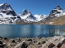
The Pequeño Alpamayo is located in the east of the Condoriri group in the La Paz department . The commonly used base camp at Laguna Chiar Khota can be reached within one day from La Paz via Tuni ( 4438 m ) and a three-hour hike past Lake Tuni .
Routes to the summit
Summit tours to the Pequeño Alpamayo usually start from the base camp at around 4700 m at Laguna Chiar Khota . To do this, the summit of Cerro Tarija must first be crossed via a glacier ascent . The normal route to the summit is an up to 55 ° steep ice tour and runs over the curved south-west ridge.
A more demanding direct route leads in III. Degrees through the 55–65 ° steep south-west wall.
Web links
- Information on the Pequeño Alpamayo , Andeshandbook.org (English)
- Pequeño Alpamayo on Peakbagger.com (English)
- Pequeño Alpamayo Summitpost.org (English)
Individual evidence
- ^ Nevado Pequeño Alpamayo . andeshandbook.com. Retrieved December 23, 2013.


