
Peters projection

The Peters projection is a map network design published by Arno Peters in 1974 . It received sustained attention and was initially widely used. The result of the map network design developed independently by Peters is identical to the Gall-Peters projection developed by James Gall (1808–1895) .
Characteristics
The Gall-Peters projection was presented in 1855 by James Gall at a meeting of the British Association for the Advancement of Science as "Gall's Orthographic Projection".
The Peters projection was developed for world maps in order to show all countries in true-to-area proportions. The cylindrical projections used for comparison ( Mercator projection or the square flat map ) are not true to area and were increasingly rejected as "Eurocentric" - not only by Peters . At the same time, a subjective element was emphasized which, through its changeability, enables the shape to be similar to surface shapes known from the globe. In addition to other attributes, a new prime meridian , a new date line and a new graticule were also part of his new development.
The result of the projections by Gall and Peters is identical.
Properties of the projection
The Peters projection can be understood as the projection of an earth ellipsoid onto a cylinder. It is true to area, position and axis. Therefore, all areas are shown on the same scale; Places of the same latitude or longitude lie on horizontal and vertical lines. In principle, it can neither be length nor true to angle . If the required form is true, the construction of individual maps is possible by defining the respective delimiting latitudes.
The preacher James Gall, Edinburgh, Scotland published his "Gall's Orthographic Projection" in an article for The Scottish Geographical Magazine in 1885 . This is an equal-area cylinder projection with the standard latitude at 45 ° N / S. The earth is based on a spherical shape. Gall projected his graticule trigonometrically.
Controversy on application
Following the publication, there were debates in which cartographers criticized Peters' approach, which was described as "naive", and technical errors. In the discussion, the shape distortions of the Peters projection were particularly criticized. Equal area alternatives - pseudocylindrical or similar projections that lead to approximately elliptical world maps - reduced the use of the Peters projection in the long term. An important part of the debate was the identity with the projection published by James Gall. When it was presented, Peters described his design as an in-house development and did not refer to Gall's projection that had been published long before.
Proponents advocated the general use of his projection, sometimes attributing properties to it that it does not have. The Mercator projection , which is true to the angle but strongly distorted the area , was accused of shifting “the proportions in favor of the northern hemisphere and thus also in favor of the white race”.
Mercator himself had made it clear that his projection published in 1569 explicitly and exclusively ad usum navigantium ("for the use of seafarers") was not suitable for geographical maps; He did not use it in his extensive atlas of 1595. Nevertheless, the traditional maps with the Mercator projection were still often used.
Application and alternatives
The Peters projection was used in the 1980 North-South Report and was adopted by several aid organizations for their public relations work. If one evaluates the pure number of published copies, after the Mercator projection and possibly the Robinson projection it is likely to be the most famous map of the world. UNICEF alone has distributed over 60 million copies. It was also used at times by other organizations for world maps, but has not become generally accepted. It also became the basis of the Peters Atlas .
Today world maps with a non-rectangular base are mostly used. The task of fidelity to the axis thus enables the fidelity of area required by Peters with significantly lower angular and shape distortions:
- The Mollweide projection , which has point-like poles, can be used in the simple form or in the lobed form according to J. P. Goode ( homolosine ). The latter achieves particularly low distortions, although the context of the map is partially lost.
- If zonal considerations are not relevant and the accuracy of the position can be given up, a Hammer-Aitov projection with curved latitudes and thus also reduced shape distortions is possible.
- The Eckert IV projection , which is in turn true to position, appears less crowded due to line-shaped poles in this area, similar to the Goode zapping.
- Frequently used also comes angle triplet projection of Oswald angle , but not exactly equal area, but mediator is applied.
- The same applies to the Robinson projection , which is often used in the USA , which maintains the positional accuracy, but which comes at the price of greater shape distortions.

Gall-Peters projection
true to
area, true to the axis
Mollweide projection
true to
area
Zappung, here Goode homolosine projection
true to area and position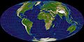
Hammer-Aitov projection
true to area
Eckert IV
true to area true to
location
Angle Tripelprojektion
mediating
Robinson projection
mediating
true to position


literature
- Arno Peters Die neue Kartographie , Carinthia University Press, Klagenfurt, 1983, ISBN 3-85378-202-7 ; German and English; originated on behalf of the University of the United Nations
- The so-called Peters projection : a statement by the German Society for Cartography . In: Geographische Rundschau 33 (1981) pp. 334-335
- Ideology instead of cartography - the truth about the "Peters World Map". Statement by the German Society for Cartography and the Association of Map Publishers in Germany from 1985 on the so-called Peter projection
- Stefan Müller: Fair world map. The controversy about the Peters projection from a historiographical perspective , in: Kurt Brunner, Thomas Horst (Hrsg.): 15. Kartographiehistorisches Colloquium . Munich, 2-4. September 2010. Lectures, reports, posters, Bonn: Kirschbaum 2012, pp. 189–208
Web links
- Explanations of the Peters projection
- Daily Mail, UK: Ten of the greatest Maps that changed the world
Individual evidence
- ↑ a b c Jeremy Crampton: Cartography's defining moment: The Peters Projection Controversy 1974-1990 . In: Cartographica . tape 31 , no. 4 , 1994, pp. 16-32 , doi : 10.3138 / 1821-6811-L372-345P .
- ^ Arno Peters: The new cartography. P. 121 ff., Carinthia University Press, Klagenfurt 1983, ISBN 3-85378-202-7 .
- ↑ Arno Peters: The new cartography , chap. Neues Weltbild , p. 146, Carinthia University Press, Klagenfurt, 1983, ISBN 3-85378-202-7
- ^ Use of Cylindrical Projections for Geographical, Astronomical, and Scientific Purposes. Retrieved January 9, 2018 .
- ↑ Seeing the world with different eyes - the world map by the Bremen historian Prof. Dr. Arno Peters. Evangelical Mission in Germany
- ↑ Jeremy Crampton: Cartography's defining moment: The Peters Projection Controversy 1974-1990 . In: Cartographica , Vol. 31 (1994), No. 4, pp. 16-32, DOI = 10.3138 / 1821-6811-L372-345P; here: p. 22.