
Pico de la Zarza
| Pico de la Zarza | ||
|---|---|---|
 |
||
| height | 807 msnm | |
| location | Fuerteventura | |
| Dominance | 118.63 km → Caldero de Urión | |
| Notch height | 807 m | |
| Coordinates | 28 ° 6 ′ 7 ″ N , 14 ° 21 ′ 20 ″ W | |
|
||
| Type | eroded stratovolcano | |
| rock | basalt | |

The Pico de la Zarza (also Pico de Jandía ) is the highest mountain on the Canary Island Fuerteventura . It is located in the southwest of the island on the Jandía peninsula . Its height is given as 807 (sometimes 812) meters.
The mountain is the remnant of a stratovolcano that rose from the sea 21 million years ago , the north-western edge of the crater of which slipped about 12 to 14 million years ago and left behind what is now the crescent-shaped Jandía massif. The north-north-western flank of the Pico de la Zarza drops steeply to the coastal plain of Cofete , while the slope to the southwest is rather gentle. From this side the summit can be easily climbed via the Tablada de Vinamar . The seven to eight kilometer long valleys Barranco de Vinámar and Barranco de Butihondo , which extend to the south coast of the island, begin at Pico de la Zarza . Neighboring peaks are the Pico de la Palma (744 m) in the west and the Pico de Mocán (801 m) in the northeast.
The Pico de la Zarza is located in the middle of the Jandía Natural Park . A lattice fence prevents goats from entering the summit area to protect the often endemic plants that grow here . Here you can find the Canarian star eye ( Asteriscus sericeus , also known as the "silky gold star") and the oleander-leaved small tree ( Senecio kleinia ), in the vicinity also the Jandía adder's head ( Echium handiense ), the thick-leaf plant Aichryson bethencourtianum and the winter daisy ( Argyranthemum) winteri ).
The PR FV 54 hiking trail leads to Pico de la Zarza . The starting point is the tourist town of Jandía Playa , a district of Morro Jable . The well-developed and marked path begins on the beach promenade and leads just below the Talahija (243 m) on a ridge up to the Degollada de Vinámar and finally to the Pico de la Zarza. The summit is reached after a distance of 7.5 km.
Picture gallery
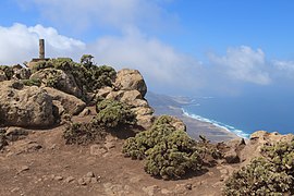
Summit of the Pico de la Zarza

View from Pico de la Zarza to Pico de Mocán (right) and the beaches of Cofete and Barlovento

Canarian star eye ( Asteriscus sericeus )
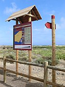
Information board at the beginning of the PR FV 54 hiking trail


Web links
Individual evidence
- ↑ a b c Pico de Jandía on Peakbagger.com (English)
- ↑ a b Stephan Scholz: La península de Jandía. Fuerteventura . In: Rincones del Atlántico 6/7, 2009–2010, accessed on March 14, 2013 (Spanish)
- ↑ a b Information on the PR FV 54 trail : Morro Jable - Pico de la Zarza on the website of the Spanish Ministry of Agriculture, Food and Environment