
Pietzmoor
_IMG_1559.jpg)
_IMG_1562.jpg)
The Pietzmoor , named after Hof Pietz to the east of the moor, is the largest contiguous moor in the Lüneburg Heath . The high moor is located southeast of the town of Schneverdingen on the southern edge of the Lüneburg Heath nature reserve . The Pietzmoor has an average peat depth of 4 m, the maximum thickness is 7.5 m.
The headwaters of the Böhme and Veerse are located in the moor . It represents a watershed between the Aller in the east and the Wümme in the west, as it drains over the Böhme to the Aller and the Veerse to the Wümme - and finally over the Aller and Wümme into the Weser .
Emergence
The moor was probably formed in the last glacial period , the Vistula glacial period , more than 10,000 years ago. Several springs developed into small spring moors that grew together to form a large fen . Over the course of around 5,000 years, sedges and peat moss created a high plant cover. This lost contact with the groundwater, so that the moor was only fed by rainwater. This created this high moor.
Flora and fauna
The crane has returned and is raising its young here. The circular hiking trail offers the opportunity to observe moor frogs , forest lizards and dragonflies . Also vipers are native here, which is why warned on corresponding signs before leaving the paths. The rare yellow bog lily (Narthecium ossifragum) is found in large stands on some fallow areas. Cotton grass (Eriophorum), sundew (Drosera), rosemary heather (Andromeda polifolia), crowberries (Empetrum) and bell heather (Erica tetralix) can be found here.
- Flora and fauna in the Pietzmoor
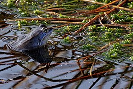
Moor frog males in the Pietzmoor during the spawning season

Juvenile forest lizard on the wooden plank trail in the Pietzmoor

Four-spot dragonfly in the Pietzmoor

Two adders in the Pietzmoor

Cotton grass in the Pietzmoor

Yellow bog lily and bell heather in the Pietzmoor


use
From the 16th century until the 1960s, the Pietzmoor was used by the surrounding farms and villages for the extraction of peat . Until the middle of the 18th century, this rural hand peat cut represented an ecologically insignificant intervention, since only little drainage took place and only small areas were pitted. From 1857 a phase of the planned drainage and exploitation of the Pietzmoors began, in which deep drainage ditches and dams were created to remove the peat. The attempt to mine peat industrially here was given up because of the lack of profitability. By 1960, 20 to 25 percent of the Pietzmoor had already been peated. In the mid-1970s, the restoration of the Pietzmoor, and later the surrounding moors, began. One of the main objectives was to restore the natural water balance of the bogs.
The north-eastern foothills of the Pietzmoorkomplex are formed by the moor at Hof Möhr and the Bockheber moor , which were also shaped by drainage and peat extraction. From 1870 to 1905 there was a brickworks on the Möhr farm whose fuel requirements were met from the Bockheber Moor. The most extensive peat extraction took place during the 1930s for the facilities of the military airfield in Reinsehlen , which later became Camp Reinsehlen . Since the mid-1980s, rewetting measures have been carried out on both moors. The Freyers Moor, the southern foothills of the Pietzmoorkomplex, has also been shaped by drainage and peat extraction.
Today the Pietzmoor is an attractive local recreation area in the nature reserve Lüneburg Heath with a size of 2.5 km². Two hiking trails (plank paths) of 4.8 km and 6.6 km in length lead directly through the moorland. Since May 2011 there is a nature adventure trail.
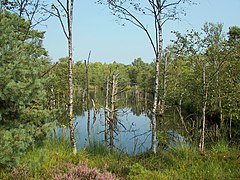
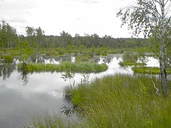
- In the Pietzmoor
Abandoned peat cut in the Pietzmoor full of water

Boardwalk through the moor
Headwaters of the Böhme in the Pietzmoor

Landscape in the Pietzmoor

_IMG_1580.jpg)


literature
- Manfred Lütkepohl: The moors . In: Cordes et al. (Ed.): Lüneburg Heath Nature Reserve. History - ecology - nature conservation . Hauschild, Bremen 1997, ISBN 3-931785-36-X , pp. 103-107.
- Manfred Lütkepohl; Jens Tönnießen: Lüneburg Heath Nature Reserve . 2nd Edition. Ellert and Richter, Hamburg 1999, ISBN 3-89234-300-4 , pp. 70-77; 162-165.
- Richard Pott: Lüneburg Heath. Wendland and Mittleres Elbe Valley National Park . Ulmer, Stuttgart 1999, ISBN 3-8001-3515-9 , pp. 156-159.
Web links
- Pietzmoor on the website of the city of Schneverdingen
- The Pietzmoor - an enchanted natural paradise on NDR.de on August 7, 2014
Individual evidence
- ^ Richard Pott: Lüneburg Heath. Wendland and Mittleres Elbe Valley National Park . Ulmer, Stuttgart 1999, p. 158f.
- ↑ Manfred Lütkepohl; Jens Tönnießen: Lüneburg Heath Nature Reserve . 2nd Edition. Ellert and Richter, Hamburg 1999, pp. 71–74.
- ↑ Manfred Lütkepohl: The Moore . In: Cordes et al. (Ed.): Lüneburg Heath Nature Reserve. History - ecology - nature conservation . Hauschild, Bremen 1997, p. 105f.
Coordinates: 53 ° 5 ′ 42 " N , 9 ° 49 ′ 32" E