Pinal Airpark
| Pinal Airpark | |
|---|---|

|
|
| Characteristics | |
| ICAO code | KMZJ |
| IATA code | MZJ |
| Coordinates | |
| Height above MSL | 577 m (1893 ft ) |
| Transport links | |
| Distance from the city center | 10 km northwest of Marana |
| Basic data | |
| opening | 1943 |
| operator | Pinal County |
| Start-and runway | |
| 12/30 | 2088 m × 45 m asphalt |
| website | |
| pinalcountyairpark.com | |
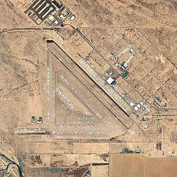
Pinal Airpark ( ICAO code : KMZJ , IATA code : MZJ , FAA code : MZJ ) is an airport in the US state of Arizona , which is used as an " aircraft graveyard ".
The airport was built in 1942 for pilot training and opened in 1943. Since it was no longer to be used for military purposes after the end of World War II , the administration was transferred to Pinal County in 1948 . During the Vietnam War , the Central Intelligence Agency operated secret flights from the airport to this day. In 1975 the site was used for the first time for the parking and recycling of decommissioned aircraft and rented to Evergreen Maintenance . Marana Aerospace Solutions has been exploiting the property since 2011 and the high security precautions that have been in place since the use of the CIA are slowly being relaxed.
From 2016, the taxiways and the runway were gradually renewed. The airport can only be approached according to visual flight rules.
Incidents
- (A) was killed on 20 September 1990, a Boeing 707-321B of Omega Air ( air vehicle registration N320MJ ) when starting from Pinal Airpark. The decommissioned passenger aircraft had been bought by Omega Air Inc. and should to Davis-Monthan Air Force Base are flown there by the 309th Aerospace Maintenance and Regeneration Group to be disassembled to the engines for machines of the United States Air Force to use . Shortly after takeoff, the machine went down, killing one of the three crew members. The investigation into the accident came to the conclusion that the master had probably worked through the checklist off the cuff and overlooked an incorrect elevator trim. In addition, the cockpit of the machine had already been partially dismantled: around 50 displays and switches that were contractually available to other recycling companies had already been removed (see also the flight accident of a Boeing 707 operated by Omega Air in 1990 ) .
Web links
Individual evidence
- ↑ a b MZJ (KMZJ) - Aeronautical Information Services. In: Federal Aviation Administration. Retrieved March 18, 2019 .
- ^ A b Scott Craven: Pinal Airpark: Once-secretive aircraft boneyard slowly opens its gates. In: azcentral.com. July 18, 2017, accessed March 18, 2019 .
- ↑ Accident report B-707 N320MJ , Aviation Safety Network (English), accessed on March 31, 2020.
