Plate (Mittersill)
| plate | ||
|---|---|---|
|
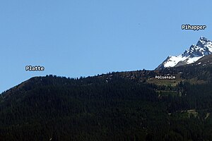
The Platte ( 1787 m ) above Mittersill, in the background the Pihapper ( 2513 m ) |
||
| height | 1787 m above sea level A. | |
| location | Mittersill in Oberpinzgau | |
| Mountains | Venediger group | |
| Dominance | 0.3 km → Pihapper | |
| Notch height | 18 m | |
| Coordinates | 47 ° 15 '27 " N , 12 ° 27' 48" E | |
|
|
||
The plate , sometimes called “Auf der Platte” in cartography, is 1787 m above sea level. A. high Grasberg in Mittersill , its summit is only slightly above the tree line. It is - viewed from the Salzach valley - upstream of the Pihapper ( 2513 m , Venediger group ). The slab is easy to walk on and can be reached from Mittersill in 2 to 3 hours, with a height difference of exactly 1000 m to be overcome. In the summit area not only abundant alpine rose and gentians grow , it also offers a wonderful panoramic view over the Salzach Valley, the Kitzbühel Alps and the Hohe Tauern .
Ascent
One possibility of ascent leads from Mittersill over the Mongweg (northeast ridge). Well-marked route via the Mong snack bar and the Aigner Hochwiese through the high forest to the summit just above the tree line.
The ascent to the Platte from Hollersbach is shorter , more precisely from the Berghof Berghof , which is 1200 m high above the Hollersbach valley , the difference in altitude is only 600 m from here. The well-marked path leads from the Berghof through the high forest and then over the Pölsenalm ( 1704 m ) to the summit.
photos
View from the Mittersill area to Platte (right) and Pihapper
Web links
Individual evidence
- ↑ Federal Office for Metrology and Surveying : Austrian Map 1: 50,000, AMAP Online , accessed on June 2, 2013


