
Pihapper
| Pihapper | ||
|---|---|---|
 The Pihapper seen from the opposite side of the Salzach Valley (Hartkaserhöhe). The pointed summit pyramid is easy to see. In the background (top left) the Großglockner (3798m) . |
||
| height | 2513 m above sea level A. | |
| location | Salzburg | |
| Mountains | Venediger group | |
| Dominance | 0.66 km → Stubenkogel | |
| Notch height | 118 m ↓ Scharte to the Stubenkogel | |
| Coordinates | 47 ° 14 '2 " N , 12 ° 27' 41" E | |
|
||

The Pihapper is a mountain in the Venediger group of the Hohe Tauern with a height of 2513 m above sea level. A. It rises as a slender peak on the border between the two Salzburg communities Mittersill and Hollersbach .
Due to its exposed location near the Salzach Valley , the Pihapper is a first-class panoramic mountain. It is a popular destination for tours in all seasons.
Ascent
From Mittersill
Well-marked route from the southern outskirts (Klausgasse - Mongweg) via the Mong snack bar and the Aigner Hochwiese through the high forest to the " Platte " (1,788 m). Then over a long ridge on the north side to the Pflugsberg ( 2414 m above sea level ) and finally through increasingly high alpine terrain to the summit. The section from the Pflugsberg is partially secured by rope and requires surefootedness and a head for heights (approx. 4½ hours).
From Hollersbach
The standard ascent from Hollersbach to the Pihapper begins at Gasthof Berghof ( 1200 m ) above the Hollersbach valley . It first leads to the Pölsenalm ( 1704 m ), then over a long north-facing ridge to the Pflugsberg ( 2414 m ) and then as described above.
photos
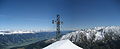
Summit with a cross, in the background the Salzach Valley and the Loferer Steinberge .
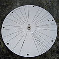
Sign with mountains that can be seen from the summit of Pihapper.

The summit pyramid of the Pihappers seen from the neighboring Pflugsberg.

Platte and Pihapper seen from the Lämmerbichl opposite

View from the Mittersill area of Pihapper and Platte

South panorama Mittersill with Felbertauern , Pihapper and Platte


Web links
Individual evidence
- ↑ Federal Office for Metrology and Surveying : Austrian Map 1: 50,000, AMAP Online , accessed on September 19, 2010