Plate purchase

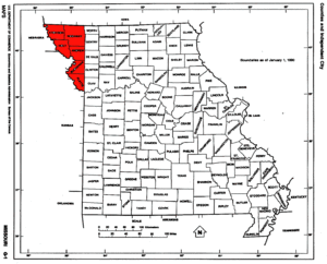
The plate purchase was a land acquisition by the United States from the Indians in 1836. 8,156 km² were added to the state of Missouri , so that its northwest boundary now corresponded to the course of the Missouri River .
The name for this land acquisition was given by the Platte River , a tributary of the Missouri, which flows through the area from Iowa .
The region includes what is now Andrew , Atchison , Buchanan , Holt , Nodaway, and Platte Counties . The northwestern districts of Kansas City , the cities of Saint Joseph , Mound City and Maryville as well as what is now Kansas City International Airport are located in the area of the Platte Purchase.
history
Indians lived on the so-called Unorganized Territory , who had been guaranteed permanent possession of these areas. Nevertheless, a number of white settlers did not adhere to this agreement and demanded the incorporation of the area they had settled into the state of Missouri.
With the tribes of Iowa and the united Sauk and Fox , a treaty was signed by William Clark in Fort Leavenworth . The tribes were paid $ 7,500; the US government set up reservations for the Indians west of the Missouri in Kansas and Nebraska . The Indians committed to settle there. The Sac and Fox Reservation and the Ioway Reservation still exist there today .
The acquired land was officially added to the State of Missouri in March 1837 by President Martin Van Buren . The western border of Missouri now formed the Missouri River to the northern border of the state. This made Missouri the largest state in the USA at the time.

