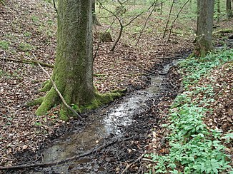
Plattengraben (Haggraben)
| Plate trench | ||
|
The slab trench just before it seeps away |
||
| Data | ||
| location |
Spessart
|
|
| River system | Rhine | |
| Drain over | Haggraben → Forchbach → Main → Rhine → North Sea | |
| source | southwest of Rückersbach 50 ° 2 ′ 17 ″ N , 9 ° 5 ′ 14 ″ E |
|
| Source height | 260 m above sea level NHN | |
| Infiltration | north of Häuserackerhof Coordinates: 50 ° 2 ′ 12 ″ N , 9 ° 4 ′ 3 ″ E 50 ° 2 ′ 12 ″ N , 9 ° 4 ′ 3 ″ E |
|
| Mouth height |
119 m above sea level NHN percolation 111 m above sea level NHN estuary |
|
| Height difference | 141 m | |
| Bottom slope | 94 ‰ | |
| length | 1.5 km | |
| Catchment area | 50 ha | |
The Plattengraben is a right, periodic tributary of the Haggraben in the Aschaffenburg district in the Bavarian Spessart .
course
The Plattengraben rises southwest of Rückersbach am Plattenberg , near the Dettinger Hütte . It runs in a westerly direction. To the north of the hutsackerhof it seeps away shortly before it leaves the forest. There is no longer a fixed stream bed below the infiltration . The Plattengraben only manages to reach the Haggraben after heavy rain or snowmelt .
The Plattengraben was at times a tributary of the Main , which once flowed into the Urmaintal, which is now crossed by the Haggraben .
See also
Web links
Commons : Disk Trench - collection of images, videos and audio files

