
Haggraben
| Haggraben | ||
 The Haggraben near Waldstadt |
||
| Data | ||
| Water code | DE : 2477122 | |
| location |
Spessart
|
|
| River system | Rhine | |
| Drain over | Forchbach → Main → Rhine → North Sea | |
| Emergence | In the Bruchwiese near Kleinostheim 50 ° 0 ′ 59 ″ N , 9 ° 3 ′ 57 ″ E |
|
| Source height | 112 m above sea level NHN | |
| muzzle | in Karlstein am Main in the Forchbach Coordinates: 50 ° 2 '22 " N , 9 ° 2' 16" E 50 ° 2 '22 " N , 9 ° 2' 16" E |
|
| Mouth height | 106 m above sea level NHN | |
| Height difference | 6 m | |
| Bottom slope | 1.2 ‰ | |
| length | 5 km | |
| Catchment area | 15 km² | |
| Right tributaries | Bruchbach , Rückersbach , Rohrwiesenbach , Plattengraben , Häggraben | |
The Haggraben or Hauptgraben is a left tributary of the Forchbach near Karlstein am Main in the Aschaffenburg district . It does not have its own spring, as it begins as stagnant water in the Bruchwiese near Kleinostheim .
geography
course
From its first tributary, the Bruchbach , it flows in a northerly direction. In the Waldstadt area the bed of the Haggraben has been dredged several times in recent years due to siltation. In summer the Haggraben often has little, sometimes no water at all, because the Bruchbach seeps into the flat reed landscape. The dry stream bed is then only fed by the Rückersbach , which flows into the Haggraben at the Schluchthof. The Rohrwiesenbach flows to the west of the hüttenackerhof . The Haggraben leaves the valley near the Autobahn 45 and flows west to Karlstein, where it flows into the Forchbach .
Tributaries
- Bruchbach ( right, temporarily dry ) 3.6 km
- Rückersbach ( right ) 4.1 km
- Rohrwiesenbach ( right, temporarily dry ) 2.5 km
- Plattengraben ( right, temporarily dry ) 1.5 km
- Häggraben ( right, temporarily dry ) 3.5 km
history
Urmaintal
The Main used to flow in the swampy area between Kleinostheim and Dettingen, which is partly under landscape protection . The Magdalen flood in 1342 left behind a lake that reached between the Dettinger Lindig and the mountains to the beginning of the Rückersbach Gorge. The lake was still marked on maps from 1680 and 1728. Today the area of the former Main Valley is not forested and can still be recognized. As a result of this severe flood, parts of the now no longer existing village of Bruchhausen are said to have been destroyed.
This Urmain continued its course in a loop around what is now Großwelzheim . A remnant of this loop of the Main is the Lange See, a natural monument .
Picture gallery

Beginning of the haggraben
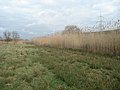
The reed area at Haggraben in the Waldstadt area

Mouth of the Haggraben (right), into the Forchbach (left)


See also
Web links
Individual evidence
- ↑ a b c d BayernAtlas of the Bavarian State Government ( notes )
- ^ District map of Alzenau : Topographic map 1: 50,000
- ^ Gerhard Nees & Hermann Kehrer: Alzenauer Wetterchronik . The most interesting weather events in Alzenau, in the Kahlgrund and on the Untermain from 365 to 1999. Reinhold Keim Verlag, Großkrotzenburg 2002, ISBN 3-921535-51-4 .
- ↑ Our Kahlgrund 1961, 1964, 1973 and 1984 . Homeland yearbook for the Alzenau district. Published by the working group for homeland research and homeland maintenance of the Alzenau district, district administrator. ISSN 0933-1328 .