Plumstead Township
| Plumstead Township | |
|---|---|
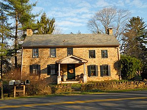
 House in Dyerstown |
|
| Location of Plumstead Township in Bucks County | |
| Basic data | |
| Foundation : | 1700 |
| State : | United States |
| State : | Pennsylvania |
| County : | Bucks County |
| Coordinates : | 40 ° 23 ′ N , 75 ° 7 ′ W |
| Time zone : | Eastern ( UTC − 5 / −4 ) |
| Residents : | 12,442 (as of 2010) |
| Population density : | 177.7 inhabitants per km 2 |
| Area : | 70 km 2 (approx. 27 mi 2 ) |
| Height : | 120 m |
| Area code : | +1 215 |
| Website : | www.plumstead.org |
| Mayor : | Carolyn McCreary |
 |
|
Plumstead Township is located in Bucks County in the state of Pennsylvania . The population is 12,442.
geography
Plumstead Township is 70.5 km², of which 70.3 km² is land and 0.1 km² is water. The Delaware River separates the township from the state of New Jersey in the east. The Ralph Stover State Park is located in Plumstead Township. Some villages in the township are Carversville (partly in Solebury Township ) Curley Hill, Danboro, Dyerstown, Fountainville, Gardenville , Groveland, Hinkletown, Kendigtown, Keplers Corner, Landisville, Lower Black Eddy, Lumberville , Melchers Corner, Plumsteadville, Point Pleasant (Pennsylvania) (partly in Tinicum Township ), Smiths Corner, Smithtown and Wismer.
Plumstead Township is bordered by the following townships:
- Solebury Township (East)
- Buckingham Township (South East)
- Doylestown (Township) (South)
- New Britain Township (South West)
- Hilltown Township (Southwest)
- Bedminster Township (northwest)
- Tinicum Township (north)
- New Jersey (Northeast)
history
Native Americans from the Lenni Lenape tribe originally settled in this area. Plumstead Township was founded around 1700 with the arrival of the first English Quakers, following William Penn's call. The first Plumstead Quaker meeting house was built in 1727. Shortly after the arrival of the Quakers, German Mennonites came to Plumstead Township and built a first church in the village of Groveland (around 1806). Afterwards, many Scots and Irish immigrated, but most of the inhabitants still have German ancestors.
It is not entirely clear where the name Plumstead comes from. One theory has it that it was derived from Francis Plumstead, an English merchant. A second theory says that one of the first four English parishioners was named Plumstead.
Around 1725, the first residents sent a petition to the Bucks County Court House to recognize Plumstead as a separate township. The first villages had already developed in the region with hotels, mills, blacksmiths, shops and farms. The Plumstead Township was conveniently located, with Point Pleasant, Pennsylvania it had access to the Delaware River and it was conveniently located between Philadelphia and Easton (now Route 611).
During the American Revolutionary War, many residents - mainly in Bucks County - were in favor of staying with England and against independence. At the time, the Doan gang - an outlaw gang - were well known from Plumstead Township. The Quaker Moses Doan formed the gang with his brothers and they work as spies against George Washington , steal horses and ambush tax collectors. In 1783 Moses Doan was shot. Moses brother joseph jr. managed to break out of prison and disappeared to Canada. Moses' other brother, Aaron Doan, was able to leave America just before he was about to be hanged on May 17, 1787. His brother Levi and cousin Abraham were hanged in Philadelphia in 1788 for supporting the British Crown.
Historic areas
There are nine historic villages in Plumstead Township, three have been added to the National Register of Historic Places:
Demographics
In 2000, 11,409 people lived in Plumstead Township. The population density was 162.2 / km². The average age is 34 years. The median income per household per year is $ 70,332 and the median income per family is $ 80,946. Men make an average of $ 56,263 and women $ 33,633 per year.
Living in the township:
- 94.1% whiteness
- 0.7% African American
- 1.7% Asians
- 0.1% Native American
- 4.7% Latino
Age structure:
- 30.9% under 18 years
- 4.9% between 18 and 24 years
- 36.9% between 25 and 44 years
- 20.8% between 45 and 64 years
- 6.5% older than 65 years
Famous pepole
- Doan gang
Individual evidence
- ↑ Cecila Ellenbogen et al: Plumstead Historocal Society. (PDF) (No longer available online.) Formerly in the original ; accessed on July 16, 2017 . ( Page no longer available , search in web archives ) Info: The link was automatically marked as defective. Please check the link according to the instructions and then remove this notice.
- ↑ The Gombach Group: Plumstead Township History. Retrieved July 16, 2017 .
- ↑ Township Website: plumstead.org. (No longer available online.) Archived from the original on July 15, 2017 ; accessed on July 16, 2017 . Info: The archive link was inserted automatically and has not yet been checked. Please check the original and archive link according to the instructions and then remove this notice.
- ^ Peter Mulcahy: The Doan Outlaws of Bucks County. (No longer available online.) Archived from the original on December 20, 2016 ; accessed on July 16, 2017 . Info: The archive link was inserted automatically and has not yet been checked. Please check the original and archive link according to the instructions and then remove this notice.
- ^ Population and Housing Unit Estimates Tables. Retrieved July 16, 2017 .
