Polana Głodówka
| Polana Głodówka | ||
|---|---|---|
|
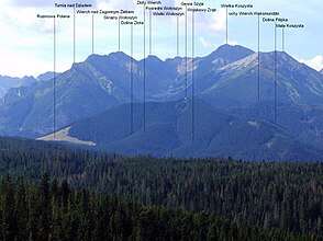
View from Polana Głodówka |
||
| location | Lesser Poland Voivodeship , Poland | |
| Mountains | High Tatras , Tatras , Carpathians | |
| Geographical location | 49 ° 18 ′ 10 ″ N , 20 ° 7 ′ 0 ″ E | |
|
|
||
| climate | High mountain climate | |
The Polana Głodówka alpine pasture is an alpine pasture in the Bukowina Tatrzańska municipality at the foot of the Polish High Tatras in the Lesser Poland Voivodeship .
It is an alpine pasture surrounded by mountain forest in south-east Poland near the border with Slovakia and the former border crossing Łysa Polana / Javorina . From here you have a view of the highest Tatra peaks. It lies at an altitude of 1070 to 1145 m above sea level. NHN in the Pogórzem Spisko-Gubałowskim mountain range on the slope of the Cyrhla nad Białką peak . On the edge of the alpine pasture, Voivodeship Road 960 runs from the center of Bukowina Tatrzańska via Panaroma road Oswald-Balzer-Weg to Alm Łysa Polana (former border crossing) and Alm Palenica Białczańska (entrance to the Tatra National Park ).
As early as 1874, the Polish painter Walery Eljasz-Radzikowski wrote about the Alm: I have traveled all over the Tatra Mountains and have to discover that there is no place where it is more beautiful.
history
The alpine pasture was created in the 17th century and is one of the few Tatra alpine pastures that continues to be used for cattle farming. It was first mentioned in 1676 when King John III. Sobieski left it to the Głód family from Groń at the foot of the High Tatras. The region is still home to many sheep pastures and the alp is still used for alpine farming. It is 6 hectares in size. There are old huts on the Alm.
tourism
There are several alpine huts on the alp that are still in use. The shepherds sell their products from the huts, especially the oscypek mountain cheese . The Schronisko Górskie ZHP Głodówka refuge, built in 1935, is also located on the mountain pasture . It can be easily reached from 960 Voivodeship Road.
literature
- Zofia Radwańska-Paryska, Witold Henryk Paryski, Wielka encyklopedia tatrzańska , Poronin, Wyd. Górskie, 2004, ISBN 83-7104-009-1 .
- Tatry Wysokie słowackie i polskie. Mapa turystyczna 1: 25.000, Warszawa, 2005/06, Polkart ISBN 83-87873-26-8 .
Web links
panorama


