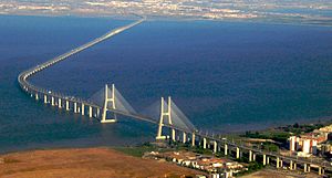
Ponte Vasco da Gama
Coordinates: 38 ° 45 ′ 55 " N , 9 ° 2 ′ 33" W.
| Ponte Vasco da Gama | ||
|---|---|---|
| use | Road traffic | |
| Crossing of | Tagus river | |
| place | Lisbon | |
| construction | Cable-stayed bridge | |
| overall length | 12,345 km (7,671 miles) | |
| width | 30 m | |
| Longest span | 420 m | |
| height | 150 m | |
| Clear height | 45 m | |
| building-costs | $ 883 million | |
| start of building | 1995 | |
| completion | 1998 | |
| opening | March 29, 1998 | |
| planner | Armando Rito , Michel Virlogeux , Charles Lavigne (architect) | |
| location | ||
|
|
||
The Ponte Vasco da Gama (German Vasco da Gama Bridge ) is a bridge with a cable-stayed bridge as the main opening that spans the Tagus River and connects Lisbon by motorway from Moscavide / Sacavém with the southeast and south-facing cities of Montijo , Alcochete and Setúbal . It was named after the Portuguese navigator Vasco da Gama and is intended to commemorate the 500 year old discovery of the sea route to India in 1498.
General
The Vasco da Gama Bridge is one of the longest bridges in Europe and the world with a length of 12.345 km . If you add the construction of the bridge with a length of 12.345 km to the construction of the road with a length of 4.84 km, the road traffic concept for this Tejo river crossing results in a route length of 17.185 km. The maximum span is 420 meters, the pylons are 155 meters high. The A12 motorway crosses the bridge with six lanes.
The bridge was built between 1995 and 1998 for the World Exhibition Expo 98 in order to relieve the Ponte 25 de Abril and other Lisbon infrastructure from north-south traffic. The Expo site and the airport can be reached directly via the Ponte Vasco da Gama.
The Vasco da Gama Bridge is owned by the country of Portugal ( República Portuguesa ). The overall project is financed with the fundamental inclusion of EU financial aid via a PPP financing model (public-private partnership) of a private consortium that receives the toll (model analogous to both Lisbon bridges) over 40 years in each refinancing, whereby The financing PPP capital for the younger Techo bridge was brought in with 24.8% by British companies, with 24.8% by French donors and 50.4% by Portuguese companies, with the Lusoponte company also operating in the model the bridge is involved.
During the construction of the bridge, a fatal accident occurred on April 10, 1997 when a metal frame collapsed and six workers were killed.
The nature reserve Parque Natural do Estuário do Tejo with its waterfowl population had to be taken into account during construction.
300 families had to be relocated to clear the foreland for the new bridge.
construction
The bridge is divided into seven sections:
- West / Lisbon access roads
- West viaduct - 488 m
- Expo Viaduct - 672 m; 12 fields
- Main part - main opening: 420 m; Side fields each: 203 m (total length: 829 m); Reinforced concrete pylon height : 150 m; Clearance height for ships at high tide : 45 m;
- Middle Viaduct - 6351 m; 80 fields made of prefabricated parts, length each 78 m; 81 piers with a depth of up to 95 m; Heights from 14 m to 30 m
- East Viaduct - 3825 m; 84 fields each 45 m; 85 pillars
- Access roads east (Montijo / Alcochete) - 3895 m; including the toll station with 18 passages and two so-called áreas de serviço (petrol stations / service area)
traffic
In Alcochete , the operating company Lusoponte levies a toll for the east-west direction (towards the city) .
Web links
- bridge-info.org: Ponte Vasco da Gama
- Ponte Vasco da Gama. In: Structurae
- Bernd Nebel: The Vasco da Gama Bridge
Individual evidence
- ^ Ponte Vasco da Gama - Taxas ( pt ) lusoponte.pt. Archived from the original on December 30, 2011. Info: The archive link was automatically inserted and not yet checked. Please check the original and archive link according to the instructions and then remove this notice. Retrieved January 2, 2012.


