Pottsville, Arkansas
| Pottsville | |
|---|---|
|
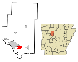
Location in county and Arkansas
|
|
| Basic data | |
| State : | United States |
| State : | Arkansas |
| County : | Pope County |
| Coordinates : | 35 ° 15 ′ N , 93 ° 3 ′ W |
| Time zone : | Central ( UTC − 6 / −5 ) |
| Residents : | 1,271 (as of: 2000) |
| Population density : | 65.5 inhabitants per km 2 |
| Area : | 19.4 km 2 (about 7 mi 2 ) of which 19.4 km 2 (about 7 mi 2 ) is land |
| Height : | 116 m |
| Postal code : | 72858 |
| Area code : | +1 479 |
| FIPS : | 05-56990 |
| GNIS ID : | 0078087 |
Pottsville is a small town in Pope County in the US state of Arkansas . It is located about 65 miles west of Little Rock and about 135 km east of Fort Smith .
After the census of 2000 the city had a population of 1,271 inhabitants. It occupies an area of 19.5 km². Pottsville is bordered by Crow Mountain to the north, Atkins to the east, and Russellville to the west .
Population development
| Population development | |||
|---|---|---|---|
| Census | Residents | ± in% | |
| 1900 | 192 | - | |
| 1910 | 205 | 6.8% | |
| 1920 | 275 | 34.1% | |
| 1930 | 293 | 6.5% | |
| 1940 | 308 | 5.1% | |
| 1950 | 224 | -27.3% | |
| 1960 | 250 | 11.6% | |
| 1970 | 411 | 64.4% | |
| 1980 | 564 | 37.2% | |
| 1990 | 984 | 74.5% | |
| 2000 | 1271 | 29.2% | |
| 1900-2000 | |||
Individual evidence
- ^ Extract from the Encyclopedia of Arkansas . Retrieved February 13, 2011
