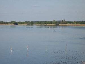
Pritzerber See
| Pritzerber See | ||
|---|---|---|

|
||
| Geographical location | Havelsee , Brandenburg , Germany | |
| Tributaries | Red moat | |
| Drain | Havel | |
| Data | ||
| Coordinates | 52 ° 30 ′ 0 ″ N , 12 ° 28 ′ 48 ″ E | |
|
|
||
| Altitude above sea level | 25 m | |
| surface | 1.9 km² | |
| Maximum depth | 6 m | |
The Pritzerber See is a lake in the middle of the Havelsee urban area . It belongs to the river system of the Havel .
description
The Pritzerber See has an area of around 190 hectares and a maximum depth of 6 meters. It drains west to the Havel. It is a eutrophic or weakly polytrophic stagnant body of water with very shallow and, especially in the south, muddy banks. The southern area between the districts of Fohrde and Hohenferchesar is accordingly completely silted up. The former town of Pritzerbe , after which the lake was named, is located on the north-western bank . Just like on the Havel, extensive bank areas on the Pritzerber See are two- and ten-year flood plains and are regularly under water. In the west, the lake is narrowed by a dam with two bridges, a railway bridge on the Brandenburg – Rathenow railway line and the road bridge on federal highway 102 between Pritzerbe and Fohrde. The only tributaries are man-made ditches. The Rote Graben flows into the lake in the northeast and feeds water from wetlands and smaller lakes, for example the White Lake and the White Fenn Marzahne . Further trenches open out at Hohenferchesar and in the south, coming from the Bruchwiesen. Several Mesolithic artifacts, for example from antlers and harpoons and fish skewers, have been found on or in the Pritzerber See . A large number of the exhibits are now in a permanent exhibition in the Jerichower Land district museum in Genthin .
As the former Reichswasserstraße , the Pritzerber See did not become a federal waterway , as it was administered by the water management authorities of the GDR on October 1, 1989 and was not taken over by the federal waterways and shipping administration until December 25, 1993 , which is why a return transfer is excluded. Since it is not formally navigable as any other body of water connected to the waterways, the Pritzerber See is closed to motorboats for nature conservation reasons .
morphology
The Pritzerber See came into being after the last, the Vistula cold period . From the north-east of Scandinavia , ice masses penetrated into Central Europe. The lake was formed in a channel basin , the Pritzerber Glacier Tongue Basin . The row of channel basins formed in the glacier tongue basin can be traced further to the northwest. For example, the White Fenn Marzahne is also part of this channel. From the south, from the Plauer See to the Pritzerber See, it is used by the Havel as a river bed. It runs parallel to the Beetzseerinne and the Bohnenlandrinne of Gördensee and Bohnenländer See in the southern connection to the Marzahn Glacier Tongue Basin . To the northeast, dunes cross the channel in the area of the Marzahner Heide and the Ketzürer Heide , so that it disappears more and more up to the Havelländischer Luch .
Protected areas
The Pritzerber See is located in several national and European protected areas. These are the nature reserve Lower Havel South , the conservation area Westhavelland which Westhavelland Nature Park , the FFH (Flora Fauna Habitat) lowlands of the Lower Havel / Gülper lake and the SPA area (European bird sanctuary) lowlands of the Lower Havel.
gallery
literature
- Hans-J. Uhlemann: Berlin and the Märkische Wasserstraßen transpress Verlag Berlin various years ISBN 3-344-00115-9
- Writings of the Association for European Inland Shipping and Waterways e. V. various years. WESKA (Western European Shipping and Harbor Calendar), Binnenschifffahrts-Verlag, Duisburg-Ruhrort
- Folke Stender: Editing of Sportschifffahrtskarten inland 1 . Nautical Publication Verlagsgesellschaft, ISBN 3-926376-10-4 , p. 19
- Collective of authors: W. Ciesla, H. Czesienski, W. Schlomm, K. Senzel, D. Weidner, shipping maps of the inland waterways of the German Democratic Republic 1: 10,000, volume 3, published by: Wasserstraßenaufsichtsamt der DDR, Berlin 1988, p. 22
Web links
Individual evidence
- ↑ Chronicle of the legal status of the Reich waterways / inland waterways of the Federation in the territory of the Federal Republic of Germany after October 3, 1990. In: gdws.wsv.bund.de. February 2013, p. 81 , accessed on May 11, 2020 .
- ↑ Frank Bürstenbinder: Conservationists keep houseboats away from Lake Pritzerber. In: maz-online.de . May 25, 2019, accessed May 23, 2020 .
- ^ Roland Weisse : Contributions to the Weichselkaltzeitlichen morphogens of the Elbhavelwinkel. Series of publications by the Faculty of Mathematics and Natural Sciences at the University of Potsdam, Potsdam April 2003, ISBN 3-935024-73-8 . P. 74, Fig. 4.4.1.
- ↑ Brandenburg an der Havel and the surrounding area, Sebastian Lentz, Böhlau Verlag GmbH & Cie, Cologne, 2006, p. 89.
- ↑ Part sheet Northwest Protected Areas. (PDF) In: Landkreis Potsdam-Mittelmark landscape framework plan. Office for Environmental and Landscape Planning, archived from the original on August 7, 2011 ; Retrieved October 16, 2013 .


