Quevedo (Ecuador)
| Quevedo | ||
|---|---|---|
|
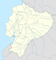
Coordinates: 1 ° 3 ′ S , 79 ° 28 ′ W Quevedo on the map of Ecuador
|
||
| Basic data | ||
| Country | Ecuador | |
| province | Los Ríos | |
| Canton | Quevedo | |
| City foundation | October 7, 1943 | |
| Residents | 158,694 (2010) | |
| - in the metropolitan area | 173,575 | |
| City insignia | ||
| Detailed data | ||
| surface | 191 km 2 | |
| Population density | 831 inhabitants / km 2 | |
| height | 74 m | |
| Waters | Río Quevedo | |
| prefix | (+593) 5 | |
| License Plate | R - - | |
| Time zone | UTC -5 | |
| City Presidency | Jorge Dominguez | |
| City patron | Virgen de las Mercedes | |
| Website | ||
Quevedo is an Ecuadorian city in the Los Ríos province . The city of Quevedo is the most populous in the province with a good 173,585 inhabitants and the twelfth largest city in Ecuador.
The city consists of nine urban districts:
- Quevedo center
- San Camilo
- Guayacan
- Nicolás Infante Díaz
- San Cristobal
- Siete de Octubre
- Venus del Río
- Viva Alfaro
- 24 de Mayo
and two rural districts:
- San Carlos
- La Esperanza
geography
Quevedo is located 240 km southwest of the capital Quito and 190 km north-northeast of Guayaquil . The port of Manta on the Pacific coast can be reached in around 2.5 hours via national road 40.
The growing city lies in a climatically favored zone of the coastal plain. The main industries of the region and the city are agriculture and food production. Bananas and cocoa are important sources of income .
economy
Quevedo is the economic center of the Los Rios province.
Numerous export companies are located in the city and have been active in the foreign trade sector for more than 50 years.


