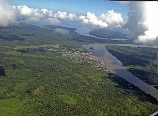
Río Guapi
| Río Guapi | ||
|
View over the city of Guapi and the River Guapi; in the background its confluence with the Pacific Ocean |
||
| Data | ||
| location |
|
|
| River system | Rio Guapi | |
| Headwaters |
Western Cordillera 2 ° 11 ′ 13 ″ N , 77 ° 34 ′ 56 ″ W. |
|
| Source height | approx. 1000 m | |
| muzzle |
Pacific Ocean Coordinates: 2 ° 38 '25 " N , 77 ° 54' 41" W 2 ° 38 '25 " N , 77 ° 54' 41" W. |
|
| Mouth height | 0 m | |
| Height difference | approx. 1000 m | |
| Bottom slope | approx. 7.6 ‰ | |
| length | approx. 132 km | |
| Catchment area | approx. 2200 km² | |
| Drain |
MQ 1981/1993 |
357 m³ / s |
| Right tributaries | Río Pilpe, Río Anapanchi, Río Napi | |
| Small towns | Guapi | |
The Río Guapi is an approximately 132 km long tributary of the Pacific Ocean in the southwest of Colombia .
River course
The Río Guapi rises in the Colombian western cordillera at an altitude of about 1000 m . Initially it flows in a westerly direction. After about 15 km it reaches the western Colombian coastal lowlands. From river kilometer 100 the Río Guapi turns north. It has numerous river loops in the middle and lower reaches . It takes on the tributaries Río Pilpe and Río Anapanchi coming from the east . At river kilometer 40 the Río Napi meets the Río Guapi coming from the east. At river kilometer 29, an estuary branches off to the north. This splits again into two arms, with the right arm flowing into the same bay as the Río Guajuí, which runs further north . The main estuary turns to the west. The town of Guapi is located 15 km above the mouth on the left bank of the river. The river then forms a large arch before it finally flows into the sea. The border between the departments of Nariño and Cauca runs at the mouth .
Catchment area and hydrology
The catchment area of the Río Guapi covers an area of about 2200 km². It is within the municipal area of Guapi. The southern and western watershed form the border with the Departamento de Nariño. The catchment area of the Río Guapi borders in the north on the catchment area of the Río Guajuí and the Río Timbiquí , in the south and west on that of the Río Iscuandé . The mean discharge is 357 m³ / s.
Individual evidence
- ^ A b Juan D. Restrepo, Björn Kjerfve: The Pacific and Caribbean Rivers of Colombia: Water Discharge, Sediment Transport and Dissolved Loads . Hydrochemical Aspects of Major Pacific and Caribbean Rivers of Colombia. January 2004. Retrieved March 15, 2019.
