Río Supe
| Río Supe | ||
|
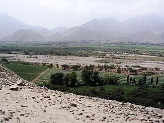
Lower reaches of the Río Supe near Caral |
||
| Data | ||
| location |
|
|
| River system | Río Supe | |
| Headwaters |
Peruvian Western Cordillera 10 ° 40 ′ 52 ″ S , 77 ° 2 ′ 49 ″ W |
|
| Source height | approx. 4900 m | |
| muzzle |
Pacific Ocean Coordinates: 10 ° 51 ′ 9 " S , 77 ° 42 ′ 37" W 10 ° 51 ′ 9 " S , 77 ° 42 ′ 37" W |
|
| Mouth height | 0 m | |
| Height difference | approx. 4900 m | |
| Bottom slope | approx. 52 ‰ | |
| length | approx. 95 km | |
| Catchment area | approx. 1020 km² | |
| Flowing lakes | Laguna Jururcocha | |
| Communities | Ámbar | |
The Río Supe is an approx. 95 km long tributary of the Pacific Ocean in central western Peru in the provinces of Huaura and Barranca in the north of the administrative region Lima . There are several archaeological sites along the lower reaches, including the Caral settlement . 5 km northwest of the estuary is the well-known archaeological site Áspero .
River course
The Río Supe rises in the Peruvian western cordillera at an altitude of approx. 4900 m . Initially it flows 3 kilometers in a southeast direction. It flows through the small mountain lake Laguna Jururcocha . The Río Supe then flows through the mountains for about 25 km in a predominantly west-southwest direction. The river passes the Ámbar district administrative center at river kilometer 64 and turns to the southwest. From river kilometer 35, the Río Supe gradually turns towards west-northwest. Shortly afterwards, the river leaves the Huaura province. The lower reaches lie within the province of Barranca. 14 km above the mouth, the river reaches the coastal lowlands and turns to the west. The lower river valley of the Río Supe is flanked in the north by the two ridges Lomas Caral-Purmacana and Lomas de Liman . The Panamericana highway crosses the river about 2.5 km above the estuary . The mouth of the Río Supe is 12 km south of the provincial capital Barranca . In the coastal lowlands extensive irrigated agriculture is practiced.
Catchment area and hydrology
The Río Supe drains an area of around 1020 km². The catchment area borders on that of the Río Pativilca to the north and that of the Río Huaura to the south . The Río Supe has very little water in the months of July to September and can sometimes fall dry.
