Rödelbach (Selke)
|
Rödelbach Rödelbachgraben |
||
|
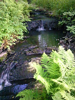
Rödelbach just behind the Malini pond |
||
| Data | ||
| Water code | DE : 568418 | |
| location | middle Lower Harz , Saxony-Anhalt | |
| River system | Elbe | |
| River basin district | Elbe | |
| Pseudobifurcation | at the foot of the silver heads 51 ° 35 ′ 30 ″ N , 11 ° 0 ′ 12 ″ E |
|
| Source height | 460 m | |
| muzzle | at Schindelbruch in Schindelbruchbach / in Straßberg in the Selke coordinates: 51 ° 37 '7 " N , 11 ° 2' 48" E 51 ° 37 '7 " N , 11 ° 2' 48" E
|
|
| Left tributaries | Bach vom Söhlenborn , Büschengraben | |
| Right tributaries | Stream from the great Silberkopf , stream from Kohlberg , Stollgraben , Dorfgraben | |
| Reservoirs flowed through | Frankenteich , Maliniusteich | |
The Rödelbach , sometimes called Rödelbachgraben and incorrectly also called Rieschengraben, is a brook that has been modified for mining purposes and integrated into the Lower Harz pond and ditch system . The Rödelbach was originally a natural stream. The artificial changes may have happened due to the mining activities within the Rödelbachtal near Straßberg in the 16th and 17th centuries.
course
Some maps locate the original source of the left source arm on the right side of the middle Kiliansteich (today part of the Kiliansteich dam ). This source arm is now considered part of the bush trench .
A pseudobifurcation at 460 m above sea level, at the foot of the Kleines Silberkopf and Großes Silberkopf , is considered to be the source of the stream .
Western Rödelbach
The brook flows west where it flows after about 1100 m, near the Stolberg district of Schindelbruch , in the Schindelbruchbach , a tributary of the Sprachenbach ( Helme river system ).
Eastern Rödelbach
To the east, the brook first flows through the Schindelbruchwiesen , where the brook from the great Silberkopf joins on the right-hand side, only to be dammed in the Frankenteich . The brook from Söhlenborn joins here on the left . The Rödelbach flows further to the Maliniusteich . Shortly before the pond the Büschengraben joins on the left, shortly afterwards on the right-hand side the brook from the Kohlberg , which has already lost a large part of its water here due to the Stollgraben .
At the root of the Malinius pond, part of the water flows around the siltation zone. From the outflow of the Malinius pond, the water flows over the Straßberger Mühlengraben into the Selke .
waterfall
The Rödelbachgraben forms a waterfall directly behind the Maliniusteich . Visible traces of the rock processing suggest an at least partially artificial origin. The water pours over stair-like cascades , overcoming a not very large difference in height.
Tributaries
The Rödelbachgraben is fed from the Büschengraben which opens into the Kiliansteich. Below the Malini pond there are tributaries from collecting ditches, some of which have long since decayed. In addition, the pond has additional small tributaries.
Below the Malinius pond, a short connecting channel branches off to the right to the tunnel ditch .
swell
- Development and current function of systems of historical mining water management in the Lower Harz . In: Wilfried Strenz, Working Group Historical Geography of the Geographical Society of the GDR (ed.): Historical-geographical research in the GDR . Hermann Haack Geographisch-Kartographische Anstalt, Gotha 1986, ISBN 3-7301-0803-4 .
Web links
- Straßberg mining firs , on strassberg-harz.de
- The Rieschengraben , on harzlife.de
