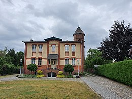
Recklin
Recklin , Lower Sorbian Reklin is a historic suburb of Lübbenau was, who founded in the 16th century and incorporated in 1688, together with the villages of mountains, Hague and Kampe in the city of Lübbenau. Today it has risen completely in the central place.
location
Recklin was in Niederlausitz and in the southern part of the Spreewald . The place was roughly in the area of today's Max-Plessner-Strasse . Immediately to the north is the old town of Lübbenau, east the place Lehde and west the place Stottoff .
history
A parcel with the name Reckling at the location of the village was first mentioned in a document in 1496, but at that time it was still undeveloped. Only when the lordship of Lübbenau came into the possession of the von der Schulenburg aristocratic family at the beginning of the 16th century , a settlement was built on the parcel. Several linen weavers were then settled there. On old maps the Recklin complex can be seen as a dead end village . The place name goes back to the Sorbian word rakolin and roughly means "place of crab catchers ".
Until 1635 Recklin belonged to the Margraviate of Lower Lusatia and was thus part of the countries of the Bohemian Crown , after the Peace of Prague the place came to the Electorate of Saxony . On May 14, 1688, Recklin was added to the Lübbenau urban area together with the towns of Berge, Haag and Kampe, which were also located outside Lübbenau. Since 1806 Recklin belonged to the newly formed Kingdom of Saxony . At the beginning of the 19th century, the place was listed as a village, Recklin has always been a parish in the parish of the Sankt Nikolai Church in Lübbenau. After the decision to partition the Kingdom of Saxony at the Congress of Vienna , Recklin passed to the Kingdom of Prussia . During the territorial reform in the following year, Recklin came to the district of Calau in the province of Brandenburg . In 1820 Recklin had 121 inhabitants.
According to the topographical-statistical overview of the administrative district of Frankfurt adO from 1844, there were 27 residential buildings in Recklin at that time, the place had a total of 148 inhabitants. By 1856 the population in Recklin rose to 168. In the following time the population of Recklin was no longer recorded separately, at least from 1867 the place no longer appeared in the topographical-statistical handbooks. In 1905 an electricity station was built in the local area of Recklin , which supplied the city of Lübbenau with light and electricity. During the GDR era, the Recklin area belonged to the Calau district in the Cottbus district and, after reunification, to the Calau district in the state of Brandenburg. The district of Calau went on December 6, 1993 in the new district of Oberspreewald-Lausitz .
Individual evidence
- ^ Paul Fahlisch : Location and gradual expansion of Lübbenau. In: History of the Spreewaldstadt Lübbenau. Lübbenau 1928, p. 91.
- ↑ Arnost Muka : Mena ds. městow a wsow. Budyšin 1928. ( dolnoserbski.de ).
- ^ Paul Fahlisch: Location and gradual expansion of Lübbenau. In: History of the Spreewaldstadt Lübbenau. Lübbenau 1928, p. 94.
- ^ Johann Daniel Friedrich Rumpf (Ed.): Complete topographical dictionary of the Prussian state. Hahn, Berlin 1820, p. 445 ( online ).
- ↑ Topographical-statistical overview of the government district of Frankfurt ad O. Gustav Harnecker's bookstore, Frankfurt a. Cit. 1844, p. 15 ( online ).
- ^ Topographical-statistical manual of the Prussian state. Publishing house of Decker's Secret Ober-Hofbuchdruckerei, Berlin 1856, p. 501 ( online ).
- ↑ Timeline 1900–2000. City of Lübbenau, accessed on June 25, 2020.
Coordinates: 51 ° 51 ′ 52.2 ″ N , 13 ° 58 ′ 1 ″ E
