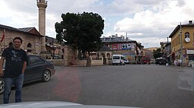
Refahiye
| Refahiye | ||||
|
||||

|
||||
| Basic data | ||||
|---|---|---|---|---|
| Province (il) : | Erzincan | |||
| Coordinates : | 39 ° 54 ' N , 38 ° 46' E | |||
| Height : | 1589 m | |||
| Residents : | 4,540 (2018) | |||
| Telephone code : | (+90) 446 | |||
| Postal code : | 24 300 | |||
| License plate : | 24 | |||
| Structure and administration (as of 2019) | ||||
| Structure : | 4 malls | |||
| Mayor : | Çakmak Paçacı ( AKP ) | |||
| Postal address : | Camiişerif Mah. 302. Sok. No: 6 / C 24300 Refahiye |
|||
| Website: | ||||
| Refahiye county | ||||
| Residents : | 12,456 (2018) | |||
| Surface: | 1,808 km² | |||
| Population density : | 7 inhabitants per km² | |||
| Kaymakam : | Hatice Bayar Özdemİr | |||
| Website (Kaymakam): | ||||
Refahiye ( Kurdish Gercan , Armenian Կերճանիս Gercanis ) is a city and administrative center of the district of the same name in the Turkish province of Erzincan and is 76 kilometers by road (about 50 km as the crow flies) west of the provincial capital Erzincan. The Kurdish name form Gercan is derived from the originally Armenian place name. The town was formerly called Gercanis and was damaged by earthquakes in 1940 and 1993. The place was raised to a municipality ( Belediye ) in 1884 .
The district borders in the south on the districts Kemah and İliç and in the east on the central district ( Merkez ) Erzincan. It has borders to the province of Sivas (3 districts) in the west and northwest, in the north to the province of Giresun (Çamoluk district) and in the north-east to the province of Gümüşhane (Şiran district). With 6.9 inhabitants per square kilometer, the district has a very low population density - like most of the districts in the east and west of the province.
The district is known for its pine forests in the west and mountains in the east. In the Dumanlı Plateau they rise up to 2000 m: Kızıldağ (2,190 m) and Sakaltutan (2,160 m). The prevailing Eastern Anatolian continental climate is harsh because of the altitude, with short and cool summers and very cold winters.
In addition to the district town, the district (2018: 36.45% of the district population) also consists of 121 villages ( Köy ) with an average of 65 residents. Yurtbaşı is the largest village with 360 inhabitants.
Personalities
- Binali Yıldırım (* 1955), shipbuilding engineer and politician of the AKP
Web links
Individual evidence
- ↑ a b Türkiye Nüfusu İl ilçe Mahalle Köy Nüfusları , accessed on June 12, 2019
- ↑ Sevan Nişanyan: Adini unutan Ülke. Türkiye'de Adı Değiştirilen Yerler Sözlüğü . Istanbul 2010, p. 129


