Pelagonia region
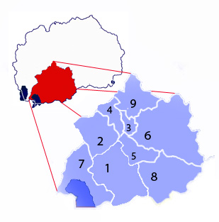
The Pelagonia region ( Macedonian Пелагониски регион Pelagoniski region , Albanian Rajoni pelagoni ) is one of the eight statistical regions , the highest administrative level in the Republic of North Macedonia . The administrative unit is divided into nine opštini, which represent the lowest administrative level. The region is located in the southwest of the country and borders Albania and Greece . Neighboring regions are the southwest region in the west and the Vardar region in the east .
Regions in North Macedonia have no administrative tasks, but only statistical purposes. In some cases, however, they form historical regions that are and were economically and culturally linked.
structure
The Pelagonia region is made up of the following nine opštini:
population

population
| year | Residents | change |
|---|---|---|
| 1994 | 214,709 | |
| 2002 | 221.019 | + 3.96% |
Biggest places
| rank | city | Residents |
|---|---|---|
| 1 | Bitola | 105,550 |
| 2 | Prilep | 66,246 |
| 3 | Resen | 8,748 |
| 4th | Kruševo | 5,570 |
| 5 | Demir Hisar | 2,593 |
Ethnic structure
The Macedonians represent the largest ethnic group , followed by the Albanians and the Roma .
| number | % | |
| All in all | 221.019 | 100.00 |
| Macedonians | 196.110 | 88.72 |
| Albanians | 8,018 | 3.62 |
| Roma | 7,054 | 3.19 |
| Turks | 4,553 | 2.06 |
| Wallachians | 2,307 | 1.04 |
| Other | 2,765 | 1.24 |
See also
Web links
numbers
- Final results of the 2002 census (PDF; 2.18 MB; English), published by the Macedonian Statistical Office; Retrieved March 27, 2011
- Edition of publications of the Census of population, households and dwellings, 2002 . Selection of various publications of the 2002 census by the Macedonian Statistical Office; Retrieved March 27, 2011
Names
- Ministry of Local Self-Government (Macedonian and Albanian), accessed March 27, 2011


