
Reiserkogel
| Reiserkogel | ||
|---|---|---|
 Reiserkogel from the northwest |
||
| height | 3082 m above sea level A. | |
| location | Tyrol , Austria | |
| Mountains | Ötztal Alps | |
| Dominance | 0.45 km → Luibiskogel | |
| Notch height | 168 m ↓ Luibisscharte | |
| Coordinates | 47 ° 2 '44 " N , 10 ° 54' 23" E | |
|
||
| First ascent | July 26, 1898 by Franz Hörtnagl, Ludwig Prochaska and Friedrich Stolz | |

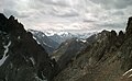
The Reiserkogel is 3082 m above sea level. A. high mountain of the Geigenkamm , a mountain range of the Ötztal Alps . It is one of the most rugged and difficult mountains on the ridge and is located south of the more frequently climbed Luibiskogel . Its steep flanks are adorned by innumerable towers and outgrowths, which give the mountain an impressive, but also repellent and dangerous appearance. Due to its dangers, it is very rarely climbed and even when climbing on the normal route there is a high risk of falling rocks. Because of the tower-reinforced north-west ridge, the mountain is popularly known as the five-finger tip . The mountain is far more conspicuous than the Luibiskogel standing next to it. To the north of it lies the frequently visited Luibisjoch.
Routes
The normal route ( UIAA II ), which is also the route of the first climber, can alternatively be reached from the Pitztal or the Ötztal . From Piösmes in the Pitztal it goes first to the Luibisalm and the Luibisboden. Follow the marked path towards Luibisjoch until you reach the scree slopes directly west of the towering Reiserkogel. Now to the southeast over a wide rubble lane to the Reiserscharte southwest of the mountain. From the Ötztal or from the Hauerseehütte over the Hauerferner to the Luibisjoch. Descending westwards you reach the scree slopes west of the mountain. Now to the southeast also on the Reiserscharte.
From the Reiserscharte there is a narrow strip of grass descending only a few meters. On it to the north along a slope and over a small rock step to the scree slopes south of the mountain. At the edge of the ridge rock over rubble up to the upper edge of a rock spur. There traverse to the east over to the entrance of a ravine-like couloir , which is steep and ribbed in the lower part. Most of the chimney-like depressions on the right can be used to overcome the bare rocky areas of the channel. To avoid the acute danger of falling rocks, the channel ascent should be completed quickly. Further up until the couloir widens and on its right edge, also threatened by falling rocks, up to a pulpit under the upper slab slopes. Now up by means of narrow cracks over a steep, green-colored line of tiles in the direction of the steep summit tower, whereby you have to switch to a neighboring crack a few times. You reach a small plateau under the summit crown. On a sloping band of scree under the summit tower until the band goes up over steep rock in the direction of the ridge. Follow the band upwards to below the steep ridge cliffs. Over flat rock steeply up to the ridge and over the Zackengrat briefly to the narrow summit crown.
An alternative but very difficult ascent leads over the northwest ridge (UIAA IV). You cross from the Luibisjoch under the first two towers and reach the Zackengrat via a rubble alley. Now very difficult over the tower-reinforced ridge to the summit.

West face of the Reiserkogel
The tower-rich NW ridge
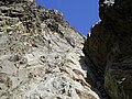
In the south couloir

Flat line, above summit tower

The summit crown

On the top


literature
- Walter Klier : Alpine Club Guide Ötztaler Alpen , Bergverlag Rudolf Rother, Munich 2006. ISBN 3-7633-1123-8
- Ludwig Obersteiner: Guide through the Ötztal Alps , Reichenstein-Verlag, Vienna 1925
Web links
Individual evidence
- ↑ according to the Federal Office for Metrology and Surveying