
Reykholt (Bláskógabyggð)
| Reykholt | |||
|---|---|---|---|
|
|||
| Coordinates | 64 ° 11 ′ N , 20 ° 32 ′ W | ||
| Basic data | |||
| Country | Iceland | ||
| Southurland | |||
| ISO 3166-2 | IS-8 | ||
| local community | Bláskógabyggð | ||
| Residents | 236 (01/01/2017) | ||
| founding | ~ 1928 | ||
 Aratunga Municipal Council
|
|||

Reykholt is a place in the south of Iceland . In Iceland it has the nickname í Árnessýslu or í Biskupstungum to distinguish it from the other place with this name.
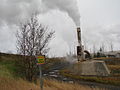
The place is located on the biscuit bride ![]() and is 96 kilometers by road from Reykjavík. It is 19 km to the geyser and 29 km to Gullfoss . Reykholtshver was a geyser that jumped about every 10 minutes. He is now taken and the hot water is used to warm z. B. used in schools and greenhouses.
and is 96 kilometers by road from Reykjavík. It is 19 km to the geyser and 29 km to Gullfoss . Reykholtshver was a geyser that jumped about every 10 minutes. He is now taken and the hot water is used to warm z. B. used in schools and greenhouses.
The municipality of Bláskógabyggð is in Reykholt . The place dates back to 1928 when a school building was built here. It was one of the first school buildings in the countryside in Iceland.

Reykholt primary school
Reykholtshver

Greenhouse in Reykholt


Individual evidence
- ↑ Fróðleikur around Reykholt. Retrieved October 30, 2017 (isl.).