Directional radio station Ansfelden
|
Directional radio station Ansfelden
|
||
|---|---|---|
| Basic data | ||
| Place: | Ansfelden | |
| State: | Upper Austria | |
| Country: | Austria | |
| Altitude : | 363 m above sea level A. | |
| Coordinates: 48 ° 12 ′ 8.3 " N , 14 ° 17 ′ 34.9" E | ||
| Use: | Telecommunications tower | |
| Accessibility: | Transmission tower not open to the public | |
| Owner : | Telekom Austria | |
| Tower data | ||
| Construction time : | 1978 | |
| Building materials : | Concrete , steel , reinforced concrete | |
| Operating time: | since September 22, 1978 | |
| Total height : | 93 m | |
| Operation room: | 50 m | |
| Data on the transmission system | ||
| Waveband : | FM transmitter | |
| Send types: | Cable headend , cellular radio , directional radio , land mobile radio , BOS radio | |
| Position map | ||
|
|
||
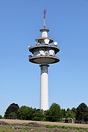
The Ansfelden directional radio station is a 93 meter high reinforced concrete tower located in the municipality of Ansfelden , Upper Austria, a few kilometers south of Linz .
It was opened on September 22, 1978 and served as a replacement for the directional radio antennas at the Fleckendorf transmitter , which was operated until the mid-1990s and whose former directional radio mast is now used by mobile network operators. The north east-west radio link Vienna-Salzburg-Innsbruck-Bregenz for telephone, television and radio, opened in 1959, runs through the station. The next relay stations are in Sonntagberg (east) and on Sulzberg near Haag am Hausruck (west). From here the branches to the telecommunications office in Linz and to the Lichtenberg transmitter will also be realized.
The concrete shaft has a diameter of around 6.5 m and a height of 76 m and was built using slipform technology. The carrier plate for the pulpit with a diameter of 20 m was concreted on the ground and hydraulically raised to 50 m. A lattice mast with a height of 17 m sits on the concrete shaft. The tower stands on a high point ( 363 m above sea level ) of the eastern foothills of the Ziehberg. The top of the tower, under which there are three platforms for transmission systems, is 456 m above sea level. A.
The owner, Telekom Austria , currently operates a directional radio node and a mobile radio system from its A1 mobile network . The tower is also used by rescue organizations. In 2006, 28 digital radio relay systems with a transmission capacity of 2.8 GB per second, which corresponds to 43,000 telephone channels or alternatively 100 - 600 video channels, and 22 analog radio relay systems for 27,000 telephone channels (alternatively 22 video channels) could be used.
The tower is very similar to the type towers of Deutsche Telekom AG and is one of four of this type in Austria. A similar tower is on the Exelberg and in Roßbrand near Radstadt.
Individual evidence
- ↑ Archived copy ( memento of the original from October 29, 2009 in the Internet Archive ) Info: The archive link was inserted automatically and has not yet been checked. Please check the original and archive link according to the instructions and then remove this notice.


