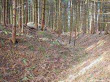
Walleshausen ring wall
The early medieval walled wall Walleshausen is located about 700 meters north of the high medieval tower hill castle of Walleshausen (municipality of Geltendorf ) in the district of Landsberg am Lech ( Upper Bavaria ) on a wooded hill. The well-preserved ground monument could be traced back to one of the numerous Hungarian fortifications in this area.
history
The relatively small weir system on the "Bockberg" above the Paartal corresponds in its good preservation and two-part system to comparable early medieval fortifications in the immediate vicinity. As with most such monuments, there is no documentary or other information about the exact time and purpose of these facilities.
Typologically, the ring wall could be assigned to the smaller Hungarian fortifications of the first half of the 10th century. Such ramparts were often created through the expansion of older settlement areas or protective castles. Approx. A section of the Roman road connection Augsburg - Brenner has been identified 250 meters northeast of the fortification (monument number D 1-7831-0100). A little further south, a group of burial mounds from the Hallstatt period can be seen in "Obereglinger Holz" (monument number D 1-7831-0021).
In the area of the battle area of the battle on the Lechfeld, there is a noticeably large number of such section fortifications or ring walls , especially on the eastern side of the Lech . According to Widukind von Corvey , the fleeing Hungarians are said to have been persecuted and worn out from these castle grounds after the battle.
Before and during the Hungarian storms , the East Franconian Empire was destabilized by numerous, sometimes extremely violent, nobility feuds. These political unrest enabled both the Hungarians and the Normans to make promising attacks on East Franconian territory. The Wallburg could have come in their final stage of development so already in the period before the Hungarians wars.
The ring wall would be one of the smallest Hungarian fortifications in the Augsburg area. The design of the weir system is reminiscent of the larger Postal Burgadelzhausen whose outer ward should also be interpreted more as a top latch.
description
The Burgplatz is only about 15 meters above the valley on a spur that juts out to the west. The ramparts were built on the northern part of this spur. Here in the north, the transition to the plateau is secured by a short, up to four meter high section wall with a trench , which merges into the steep slope after about 20 meters.
The actual, roughly circular ring wall (approx. 70 × 70 meters) is set back about 20 meters from the western slope edge. In the north, the upstream section wall and the slope edge form a narrow vestibule that only appears to have been created as gate protection. To the west, this Vorwerk widens to a small plateau , which was reinforced in the south by a section wall in the manner of the main wall.
Towards the interior, the wall crown of the main plant elevates the site by an average of two meters. The circular moat is another two meters deep. In the northeast, the outer wall height in the area of an assumed outer gate is up to six meters.
The main wall against the western outer bailey is only about two meters high. An earth bridge enables access to the core plant through a wall gap. To the left of this possibly modern entrance, traces of the terrain indicate a small early medieval gate. The approximately six meter long Torgasse was probably only 1.5 to two meters wide.
The Bavarian State Office for Monument Preservation lists the ground monument as a ring wall of prehistoric times under the monument number D 1-7831-0022.
Individual evidence
- ^ Bavarian State Office for Monument Preservation: Entry
- ^ Bavarian State Office for Monument Preservation: Entry
- ^ Bavarian State Office for Monument Preservation: Entry
Coordinates: 48 ° 9 ′ 39.3 ″ N , 10 ° 59 ′ 14.9 ″ E


