
Burgstall Walleshausen
| Burgstall Walleshausen | ||
|---|---|---|
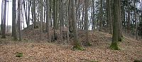
 Burgstall Walleshausen - The moat of the southwestern outer bailey. In the background the tower hill (September 2006) |
||
| Alternative name (s): | Purzelberg | |
| Creation time : | High Middle Ages | |
| Castle type : | Hilltop castle, spur position, moth | |
| Conservation status: | Burgstall, several deep trenches have been preserved | |
| Place: | Geltendorf - Walleshausen - "Purzelberg" | |
| Geographical location | 48 ° 9 '17.2 " N , 10 ° 59' 6.6" E | |
| Height: | 580 m above sea level NN | |
|
||

The Burgstall Walleshausen , also called Purzelberg , is an abandoned high medieval hill castle at 580 m above sea level. NN about 700 meters northeast of the parish church of Are Dorfer community part Walleshausen ( district Landsberg am Lech , Upper Bavaria ) on the eastern edge of the valley. In addition to the mighty tower hill (Motte), the earthworks of the two outer castles have been preserved.
history
In 1192 a Konrad von "Wegelinshusin" and his son Friedrich appear in a document. At that time, both were invited to Landsberg am Lech together with other nobles on the occasion of a negotiation between the Wessobrunn monastery and Vogt Heinrich von Stoffen.
The spacious castle stable on the "Purzelberg" (Burgselberg) shows the typical layout of a high medieval manor house , so that it can certainly be addressed as the residence of the Lords of Walleshausen. Only a few signs of an older predecessor castle can be seen in the area. Perhaps the high earth walls of the outer castles indicate such a fortification. However, only about 700 meters to the north, an apparently early medieval ring wall has been preserved, which perhaps goes back to one of the numerous smaller Hungarian fortifications in this area ( Walleshausen ring wall ).
From the sparse local historical literature it is not clear whether the fortress above the place can be assigned to a noble family or a servant family . The considerable size of the ground monument and the elevated location suggest that the lords of the castle were of noble origin. However, later such families often submitted to more powerful dynasts or concluded service contracts with these feudal lords.
In 1391, the Judmann family at Walleshausen and Petzenhofen were able to compete. The sources do not reveal whether the castle above the Paartal was still in use at that time.
The well-preserved high moth has so far hardly been taken into account by research. In addition to the Kissing and Althegnenberg castle stables , the complex is one of the most vivid examples of a tower hill castle in the Augsburg area.
description
The Burgplatz is only about 25 to 30 meters above the valley floor. To the west, the steep slope and a ditch protect the weir system. The tower hill and the two outer castles are separated from the ridge by a neck ditch up to five meters deep .
The main castle in the southeast, with its truncated conical shape, is reminiscent of the castle on the outskirts of Kissing that was probably around the same time . The tower hill is about ten meters high, the rectangular plateau is only accessible via the steep flanks.
To the west and north, the core castle was presented with two bailies. High earth walls are piled up over the inner edge of the ditch. In the northeast, an approximately five-meter-high embankment indicates a tower.
The south-western Vorwerk on the slope edge is separated from the northern outer bailey and the main castle cone by an angled inner ditch. The trench profile was obscured after 2000 by the construction of a wood removal path in front of the tower hill. This also resulted in damage to the ramparts and the destruction of some geologically interesting Nagelfluh banks on the edge of the ditch.
Like the high embankments of the bailey ramparts, the western slope moat , which is up to two meters deep, is reminiscent of early medieval fortification concepts. The plateaus of the outer castles are about ten meters below the bottom of the trench.
The Bavarian State Office for Monument Preservation lists the ground monument as a medieval hilltop castle with core work and outer bailey under monument number D 1-7831-0023.

The tower hill from the northeast (September 2006)

The east wall of the northern outer bailey. Looking south to the tower hill (September 2006)
The north wall of the castle complex with the tower (September 2006)


literature
- Bernhard Müller-Hahl (Ed.): Home book for the Landsberg am Lech district - with the city and all communities (Between Lech and Ammersee, Volume 1). 2nd revised edition, Landsberg am Lech 1982.
Individual evidence

.jpg)
Castles: Greifenberg Castle | Hurlach Castle | Igling Castle | Kaltenberg Castle | Martinsbrunn Palace (exited) | Pöring Castle | Unterdießen Castle | Windach Castle
Castles and ruins: Eresing Castle (dismissed) | Holdberg Castle ruins | Lichtenberg Castle (exited) | Landsberg Castle (exited) | Rauenlechsberg Castle ( dismissed )
Tower hill castles (all gone): Burg Sandau | Burgstall Walleshausen
Castle stables (lost, unknown castles): Burgstall Auf der Burg | Burgstall Denklingen | Burgstall Im Bichel | Burgstall laughter | Burgstall Lechsberg | Burgstall Ödenburg | Burgstall Rott | Burgstall Scheuring | Burgstall Schönenberg (Schatzberg) | Burgstall fabrics | Burgstall Stoffersberg | Wengen Castle Stables | Burgstall Windach