Río Yaguarón
| Río Yaguarón, Rio Jaguarão | ||
| Data | ||
| location | South America , Brazil , Uruguay | |
| River system | Canal Sao Gonçalo | |
| Drain over | Laguna Merín → Canal São Gonçalo → Lagoa dos Patos → Atlantic | |
| source | in the Cuchilla de las Flores near Bagé | |
| muzzle |
Laguna Merín Coordinates: 32 ° 39 ′ 14 " S , 53 ° 10 ′ 56" W 32 ° 39 ′ 14 " S , 53 ° 10 ′ 56" W.
|
|
| length | 270 km | |
| Catchment area | 3000 km² | |
| Medium-sized cities | Jaguarão , Río Branco | |
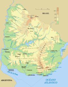
The Río Yaguarón (Portuguese: Rio Jaguarão ) is a river in South America .
It rises in the Cuchilla de las Flores near the Brazilian city of Bagé . From there it flows through Brazil's southernmost state, Rio Grande do Sul, to the border with neighboring Uruguay , which it forms from now on on its way to the mouth of the Laguna Merín in the Uruguayan department of Cerro Largo . The easternmost point of the state of Uruguay is also located at this point. The approximately 270 km long river with a catchment area of approximately 3000 km² leads on the last kilometers of its course through the two cities Jaguarão and Río Branco located on the opposite banks and connected by the Puente Internacional Barón de Mauá .
Individual evidence
- ↑ Unidades Geoestadísticas (UGeo) - Uruguay - Algunos datos de referencia ( Memento of the original from November 6, 2013 on WebCite ) Info: The archive link was automatically inserted and not yet checked. Please check the original and archive link according to the instructions and then remove this notice. (Spanish) from www.ine.gub.uy, accessed February 22, 2014

