
Cerro Largo Department
| Cerro Largo Department | |||
|---|---|---|---|
  |
|||
| Symbols | |||
|
|||
| Basic data | |||
| Country | Uruguay | ||
| Capital | Melo | ||
| surface | 13,648 km² | ||
| Residents | 84,698 (2011) | ||
| density | 6.2 inhabitants per km² | ||
| ISO 3166-2 | UY-CL | ||
| Website | www.cerrolargo.gub.uy (Spanish) | ||
| politics | |||
| Intendant | Sergio Botana | ||
| Political party | Partido Nacional | ||


Coordinates: 32 ° 27 ′ S , 54 ° 20 ′ W
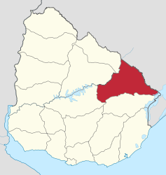
Cerro Largo is a department of Uruguay .
geography
location
It is located in the east of the country and borders the departments of Rivera , Tacuarembó , Durazno and Treinta y Tres, as well as Brazil .
Landscape image
The Cuchilla Grande range of hills crosses the department and divides the catchment area of the Río Negro in the northwest of the department from the catchment area of the Laguna Merín in the southeast.
The area in the south is hilly and covered with a carpet of crystalline stones, in the north and center the landscape is rather rugged and steep. This is due to the Cuchilla Grande located there - a large mountain range that stretches from the northeast to the southeast and branches out into other smaller mountain ranges such as the Cuchilla de Mangrullo and the Cuchilla de Cerro Largo, to then stand out as Cerro de Tupambaé . La Cuchilla Grande forms a watershed that separates the basin of the Merín lagoon from the Río Negro.
Natural resources
At the Estancia El Aguila in the southeast of the department there are crude oil deposits. There are also uranium deposits at Fraile Muerto . Bañado de Medina has montmorillonite .
Settlement structure
In addition to the capital Melo , in which more than half of the department's population (51,830 inhabitants) live, there is another important city, Río Branco (13,456 inhabitants) on the border with Brazil, which is opposite the Brazilian city of Yaguarón . Founded around 1831, it was first called Villa de San Servando, then Villa de Artigas and only since 1910 Río Branco. All goods imported from Europe and Brazil were cleared here. In addition, there are other larger settlements such as Fraile Muerto , Isidoro Noblía , Aceguá and Tupambaé in the area of the department.
Residents
While 86,564 inhabitants were counted in 2004, the number of inhabitants determined in the 2011 census was 84,698. Of these, 41,050 were men and 43,648 women.
politics
Sergio Botana of the Partido Nacional holds the leading position of the executive branch of the department, the office of the intendente .
Infrastructure
education
Cerro Largo has a total of six secondary schools ( Liceos ), in which 6,888 students are taught by 477 teachers. Half of the Liceos are located in the capital of the department, Melo, where the department's oldest , Liceo Nº 1 "Juana de Ibarbourou" , founded in 1912, is also located. (As of December 2008)
traffic
In the area of the department there is a connection to the air traffic with the nearby Melo airport Cerro Largo . The Montevideo - Nico Pérez - Río Branco or Montevideo - Nico Pérez - Melo railway runs through the department . In addition, the following roads run through the department: Ruta 7 , Ruta 8 , Ruta 18 and Ruta 26 .
Web links
Individual evidence
- ↑ Ulises Rubens Grub : Atlas geografico de la República Oriental del Uruguay, Montevideo 1980, p. 35
- ↑ Statistical data of the 2011 census ( memento of the original from September 27, 2015 in the Internet Archive ) Info: The archive link was inserted automatically and has not yet been checked. Please check the original and archive link according to the instructions and then remove this notice. of the Instituto Nacional de Estadística de Uruguay , accessed on August 29, 2012 (XLS file; 25 kB)
- ↑ Liceos del Uruguay (Spanish) (PDF; 7.3 MB), accessed on February 29, 2012
- ↑ Ulises Rubens Grub : Atlas geografico de la República Oriental del Uruguay, Montevideo 1980, p. 37
- ↑ Ulises Rubens Grub : Atlas geografico de la República Oriental del Uruguay, Montevideo 1980, p. 39
Artigas | Canelones | Cerro Largo | Colonia | Durazno | Flores | Florida | Lavalleja | Maldonado | Montevideo | Paysandú | Río Negro | Rivera | Rocha | Somersault | San José | Soriano | Tacuarembó | Treinta y Tres