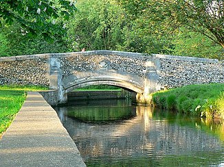
River Wandle
| River Wandle | ||
|
Walk in Beddington Park |
||
| Data | ||
| location | London and Surrey , England | |
| River system | Thames | |
| Drain over | Thames → North Sea | |
| source | Waddon Ponds, Carshalton Ponds 51 ° 22 ′ 17 ″ N , 0 ° 7 ′ 15 ″ W. |
|
| Source height | 35 m ASL | |
| muzzle | in the Thames Coordinates: 51 ° 27 ′ 46 " N , 0 ° 11 ′ 42" W 51 ° 27 ′ 46 " N , 0 ° 11 ′ 42" W. |
|
| Mouth height | 2 m ASL | |
| Height difference | 33 m | |
| Bottom slope | 2.4 ‰ | |
| length | 14 km | |
| Big cities | London Croydon , London Sutton , London Merton , London Wandsworth | |
The Wandle is an orographically right tributary of the Thames in the city of London . It gets its name from the old English Wendlesworth , German "Wendles Siedlung". With a length of only 14 kilometers it was one of the most economically used rivers by mills in the 19th century.
course
The Wandle draws its water from the limestone subsoil of the North Downs , a mountain range south of London. The main spring, the Waddon Ponds in Croydon , and the secondary spring , the Carshalton Ponds in Sutton, are located on the northern source horizon of the North Downs at about 35 meters . Ditches and streams running south of the ponds, which mostly only carried water when it was raining heavily and which were historic upper reaches of the Wandle, were built over.
From the Waddon Ponds, the Wandle flows around two and a half kilometers to the west, where it joins its roughly one kilometer long tributary river from the Carshalton Ponds. There it changes direction and flows north-northwest to the Thames.
history
Due to its proximity to London and the high gradient on a short stretch of river, the Wandle was used early on to drive water mills. The Domesday Book of 1086 names 13 mills on its course. In 1805 there were twelve cotton mills, nine flour mills, five snuff mills, five oil mills, three bleaching plants, two dye works and a paper mill, a sawmill and a copper mill and a brewery on the river.
With the advance of steam engines, the economic structure on the Wandle changed. Factories for the production of paints, solvents and other chemicals were established, the sewage of which was discharged into the river. In the 1960s, the Wandle was finally officially declared a sewer. Residents saw the river in the following years "red, pink or blue, depending on the dye they used in the tanneries" (" red, pink or blue, depending on the dye they were using in the tanneries ").
In the 1970s and 1980s, work began to improve the water quality. Among other things, this concerned the modernization of the sewage treatment plant in Beddington, from which the Wandle gets 80% of its water. The success of the renaturation and the reintroduction of fish suffered a setback on September 17, 2007 when sodium hypochlorite , which was used for cleaning at the Beddington sewage treatment plant, ran into the river and severely damaged the ecosystem over a distance of five kilometers. Thames Water , the operator of the treatment plant, was then fined £ 125,000, the UK's largest water pollution penalty to date.
Surrounding area
In 2001 the Wandle Trust was founded, which takes care of the renaturation of the river and the improvement of its environment. There is an 18 kilometer long bike and hiking path, the Wandle Trail, from the ponds to the mouth. The creation of the Wandle Valley Regional Park is planned for the future, which will provide open spaces for nature conservation and leisure activities and provide information about the history of the Wandle.
Individual evidence
- ↑ a b Ordnance Survey
- ^ Thames Water
- ↑ Press release of the Environment Agency ( Memento of the original from June 5, 2011 in the Internet Archive ) Info: The archive link was inserted automatically and has not yet been checked. Please check the original and archive link according to the instructions and then remove this notice.

