Rivière Montmorency
| Rivière Montmorency | ||
|
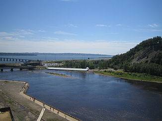
Mouth of the Rivière Montmorency |
||
| Data | ||
| location | Capitale-Nationale in Québec (Canada) | |
| River system | Saint Lawrence River | |
| Drain over | Saint Lawrence River → Atlantic Ocean | |
| origin |
Lac Subulé 47 ° 34 '24 " N , 71 ° 4' 44" W. |
|
| Source height | approx. 840 m | |
| muzzle |
St. Lawrence River Coordinates: 46 ° 53 '6 " N , 71 ° 8' 34" W 46 ° 53 '6 " N , 71 ° 8' 34" W
|
|
| length | 97 km | |
| Catchment area | 1101 km² | |
| Discharge at the gauge 0.6 km above the Barrage des Marches Naturelles A Eo : 1100 km² |
MQ 1926/2005 Mq 1926/2005 |
35 m³ / s 31.8 l / (s km²) |
| Left tributaries | Rivière des Neiges | |
| Big cities | Quebec | |
| Montmorency case | ||
|
Montmorency case |
||
The Rivière Montmorency is a left tributary of the Saint Lawrence River in the Canadian province of Québec .
The Rivière Montmorency has its origin in Lac Subulé in the Réserve faunique des Laurentides between the two larger lakes Lac Jacques-Cartier and Lac Malbaie . In the upper reaches it is fed by the neighboring lakes Lac Montmorency and Lac Alyse . The Rivière Montmorency flows in a predominantly southerly direction through the Laurentine Mountains of the regional county municipality of La Côte-de-Beaupré in the administrative region of Capitale-Nationale . Shortly before its mouth, the river overcomes the 83 m high Montmorency Falls . The confluence with the Saint Lawrence River opposite the Île d'Orléans is located 10 km north of the center of the provincial capital Québec in the Arrondissement Beauport . The Rivière Montmorency has a length of 97 km. The catchment area covers 1101 km². The mean discharge is 35 m³ / s.
Hydropower plants
The Barrage des Marches-Naturelles has been located about one kilometer above the Montmorency waterfall since 1908 . In the years 1994–1995 the associated run-of-river power station ( ⊙ ) was renewed by Boralex . It has an installed capacity of 4.5 MW at a drop height m of 18.8.
Web links
Individual evidence
- ↑ a b Office of Public Audiques sur l'environnement (PDF; 103 kB)
- ^ Commission de toponymie due Québec: Rivière Montmorency
- ↑ Water Survey of Canada: Station 02PD002 ( Memento of the original dated December 24, 2010) Info: The archive link was automatically inserted and not yet checked. Please check the original and archive link according to the instructions and then remove this notice.
- ↑ Commission de toponymie du Québec: Barrage des Marches-Naturelles
- ↑ a b boralex.com (PDF)

