
Rivière Rupert
|
Rivière Rupert Rupert River |
||
 |
||
| Data | ||
| location | Jamésie , North du Québec in Québec (Canada) | |
| River system | Rivière Rupert | |
| origin |
Lac Mistassini 50 ° 57 ′ 0 ″ N , 73 ° 42 ′ 0 ″ W. |
|
| Source height | 372 m | |
| muzzle | at Waskaganish in Rupert Bay ( Hudson Bay ) Coordinates: 51 ° 29 ′ 0 ″ N , 78 ° 46 ′ 0 ″ W 51 ° 29 ′ 0 ″ N , 78 ° 46 ′ 0 ″ W |
|
| Mouth height | 0 m | |
| Height difference | 372 m | |
| Bottom slope | 0.49 ‰ | |
| length | 763 km | |
| Catchment area | 43,400 km² | |
| Drain |
MQ |
423 m³ / s |
| Left tributaries | Rivière Natastan , Rivière à la Marte | |
| Right tributaries | Rivière Lemare , Rivière Nemiscau | |
| Flowing lakes | Lac Woollett , Lac Mesgouez , Lac Nemiscau | |
| Communities | Waskaganish | |
| Part of the water is diverted to the Robert-Bourassa Reservoir | ||
 Rupert - orig. Catchment area in yellow and orange, today derived area in orange |
||
The Rivière Rupert ( French ) or Rupert River ( English ) is one of the largest rivers in Québec , Canada .
From its source in Lake Mistassini , the largest natural lake in Québec, it flows 600 km west to Rupert Bay and James Bay . Measured from the source of the tributary Rivière Témiscamie , the river length is 763 km. The original catchment area of the Rupert covered 43,400 km².
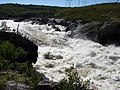
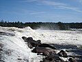
There are very difficult whitewater stretches along the Rupert. Canoeists can avoid this via portage routes on the bank. The most impressive waterfalls are the Oatmeal Rapids just off James Bay Road (a series of cascades with a height difference of 18 m) and The Fours near the end of the river (24 m drop).
The Rupert was an important Cree river in this region for a long time . Every year a group of young Cree make their way upstream from their settlement Waskaganish at the mouth of the Rupert to Lac Nemiscau . A bridge leads over the Rivière Rupert along the Route de la Baie James .
River diversion
Since November 2009, part of the water from the Rupert River has been diverted to the north as part of the Baie James hydropower project . Now the mean discharge at its mouth is only 423 m³ / s instead of the original 900 m³ / s.
The main tributaries of the Rupert are (downstream):
- Rivière Natastan / Natastan River
- Rivière Lemare / Lemare River - 1290 km² catchment area
- Rivière à la Marte / Marten River - 4505 km² catchment area
- Rivière Nemiscau / Nemiscau River - 3015 km² catchment area
photos
Rupert on the Route du Nord

Rupert River Lookout

Rupert on James Bay Road
Oatmeal Rapids


,_Oatmeal_Rapids.jpg)
Web links
- The Rupert River website
- James Bay region of Quebec. James Bay Road website
- Save the Rupert
- Rupert Reverence
- The Rupert Hydroelectric Diversion Hydro-Québec
- Environmental assessment process and documents. Ministry of the Environment of Québec (French)
- Environmental assessment process and documents (Canadian Environmental Assessment Agency)
- Hydro-Electric Project to Reshape Wilderness. NPR radio report, July 14, 2008
- Rezmutt's Flickr.com Rupert River Archive
- The Rupert River (YouTube video)
Individual evidence
- ↑ The Atlas of Canada - Lakes ( Memento from January 14, 2013 in the Internet Archive ) (English)
- ↑ Measured to the head of Rivière Témiscamie; source: Natural Resources Canada, The Atlas of Canada - Rivers ( Memento from January 22, 2013 in the Internet Archive ) (English)
- ↑ Original watershed; source: Natural Resources Canada, The Atlas of Canada - Rivers ( Memento from January 22, 2013 in the Internet Archive ) (English)