Rohrbach (Glatt)
|
Rohrbach Rorbach, Mülitobelbach (OL) |
||
|
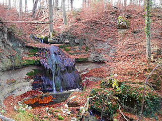
View of the Rohrbach ravine with a waterfall on the municipal boundary of Fällanden (left) and Maur |
||
| Data | ||
| Water code | CH : 13378 | |
| location | Switzerland | |
| River system | Rhine | |
| Drain over | Glatt → Rhine → North Sea | |
| source | in the Bergwisen corridor in Ebmatingen 47 ° 20 ′ 54 ″ N , 8 ° 38 ′ 23 ″ E |
|
| Source height | approx. 639 m above sea level M. | |
| muzzle | at the Rohr Maur farm in Greifensee Coordinates: 47 ° 22 '0 " N , 8 ° 39' 11" E ; CH1903: 691.73 thousand / 246925 47 ° 22 '0 " N , 8 ° 39' 11" O |
|
| Mouth height | 435 m above sea level M. | |
| Height difference | approx. 204 m | |
| Bottom slope | approx. 73 ‰ | |
| length | 2.8 km | |
| Catchment area | 1.58 km² | |
| Right tributaries | Ruetibach | |
| Communities | Maur , Fällanden | |
|
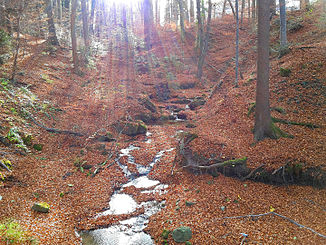
View into the upper Rohrbach Tobel |
||
The Rohrbach (also Rorbach , in the upper reaches of Mülitobelbach ) is an approximately three kilometer long tributary of the Greifensee in the communities of Maur and Fällanden in the Swiss canton of Zurich . It drains a 1.6-square-kilometer section on the eastern slope of the Pfannenstiel -Hügelzugs and flows through it Ebmatingen before it between the forest areas Müliholz and Balm a deeply carved ravines forms.
geography
course
The stream rises as Mülitobelbach at about 639 m above sea level. M. in the Bergwisen district in the southern part of the village of Ebmatingen. The gutted spring is located on Chalenstrasse below a parking lot in a residential area. From here it initially flows to the northwest and comes to the surface for the first time after a 160 meter long stream. It flows through a meadow and passes three houses in the Churzbach district before, after about 70 meters, it crosses under Chalenstrasse and emerges again in a forest edge.
It turns to the northeast and forms the small Mülitobel for around 130 meters before it is overturned again. It crosses under the village center of Ebmatingen and flows openly again from the post office. The stream is now again accompanied by a forest fringe, which is only briefly interrupted by a neighborhood street.
It leaves the built-up area and is bordered on the left by a meadow and on the right by a field, before the Lohwis district adjoins the right bank for a short section , which forms the northeasternmost part of Ebmatingen. After crossing under Lohwisstrasse , it is called Rohrbach and at the same time forms a small ravine , which briefly borders the Hinderwis industrial zone on the left before it reaches the Müliholz forest . It takes its only tributary, the Rütibach, from the right and now mostly flows north. On a short section it forms the municipal boundary between Maur and Fällanden.
The ravine is now getting deeper and deeper and it passes a six meter high waterfall before turning back to the northeast. An eight-meter-high waterfall and other small waterfalls follow between Müliholz and Chilenholz , before the ravine slowly flattens out again at Limet . It is again accompanied by a forest border, which is bordered on both sides by fields. Before crossing under the Fällanden - Maur road , it flows through a sediment barrier , which is cleared of debris every year. It now passes the Rohr farm and finally flows out at 435 m above sea level. M. to the south bank of the Greifensee.
Catchment area
The 1.58 square kilometer catchment area is located in the municipalities of Maur and Fällanden. It consists of 57.4% built-up area, 32.6% agricultural area, 9.9% near-natural area and forest and 0.1% water area.
The highest point is 686 m above sea level. M. reached at Süessblätz below the Guglen . The average altitude is 593 m above sea level. M.
In the north and west lies the catchment area of the Jörenbach and in the southeast that of the Aschbach , which also drains into the Greifensee. In the southwest is that of the Werenbach , which flows into Lake Zurich .
Web links
- Course of the Rohrbach on GIS Zurich
- Course of the Rohrbach on the geoserver of the Swiss federal administration
Individual evidence
- ↑ a b individual records of the geographic information system of the canton of Zurich
- ↑ a b c Geoserver of the Swiss Federal Administration ( information )
- ↑ Fällanden nature trails Fällander Naturschutzverein.
- ↑ catchment area of the Rohrbach. In: Topographical catchment areas of Swiss waters: area outlets. Retrieved November 24, 2015 .

