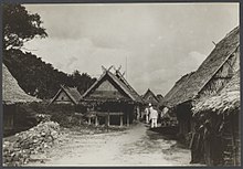
Romang (island)
| Romang | ||
|---|---|---|
| Romang and its neighboring islands | ||
| Waters | Banda Lake | |
| Archipelago | Barat Daya Islands | |
| Geographical location | 7 ° 34 ′ S , 127 ° 24 ′ E | |
|
|
||
| surface | 168.2 km² | |
| Residents | 3884 (2010) 23 inhabitants / km² |
|
| main place | Hila | |
Romang ( Roma , Indon .: Pulau Romang ) is one of the Indonesian Barat Daya Islands ( Southwest Islands ) in the Banda Sea .
geography
Romang is east of Wetar and the Strait of Romang . To the south are the Leti Islands and Kisar . To the west lies Damar with a few small islands. Romang belongs to the inner ribbon bow .
Romang is also surrounded by smaller islands. To the northwest lies Njata , southwest Mitan and east Tellang , Limtutu , Laut , Kital , Maopora and Djuha .
Romang belongs to the Kecamatan (sub-district) Pulau-Pulau Terselatan , Kabupaten (administrative district), Southwest Moluccas ( Maluku Barat Daya ), Maluku Province .
Residents
The three Desa of the island are called Hila (2010 population: 1,262), Jerusu (2,138) and Solath (484).
The Malayo-Polynesian language Romang is spoken around Jerusu . In 1991 there were 1,700 speakers of this language.
economy
On Romang there are deposits of copper, gold, lead, silver, zinc and manganese.
Web links
Individual evidence
- ↑ Penduduk Indonesia menurut desa 2010 ( Memento from March 27, 2014 in the Internet Archive ) (Indonesian; PDF; 6.0 MB), accessed on April 24, 2014
- ↑ Ethnologue: Roma
- ^ Company & Property Mine: Romang Island
- ^ Asia Miner: INDONESIA - Record Romang Island manganese intersection


