Romatschachen
|
Romatschachen ( Rotte ) locality cadastral community Romatschachen |
||
|---|---|---|
|
|
||
| Basic data | ||
| Pole. District , state | Weiz (WZ), Styria | |
| Judicial district | Wheat | |
| Pole. local community | Pischelsdorf am Kulm | |
| Coordinates | 47 ° 11 '39 " N , 15 ° 47' 37" E | |
| height | 420 m above sea level A. | |
| Residents of the village | 428 (January 1, 2020) | |
| Area d. KG | 5.36 | |
| Statistical identification | ||
| Locality code | 16331 | |
| Cadastral parish number | 68146 | |
| Counting district / district | Pischelsdorf area (61764 001) | |
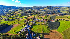
 Aerial view |
||
| Source: STAT : index of places ; BEV : GEONAM ; GIS-Stmk | ||
Romatschachen is a village and a cadastral municipality in the municipality of Pischelsdorf am Kulm in the Weiz district in Styria .
The Rotte is located north of Pischelsdorf at 420 m above sea level. A. . The two-line village complex was created secondary. The founding farm was initially divided into four and in the 15th century into eight farms. The second row of streets was laid out when it was divided into eight courtyards. In the 18th century, more courtyards were split off. The scattered settlements Hollerberg and Romatschachberg also belong to the village of Romatschachen.
Individual evidence
- ^ Rene Mayr: Settlement morphological analysis Pischelsdorf . epubli, Berlin 2014, ISBN 978-3-7375-0006-7 ( limited preview in the Google book search).
