
Ron (Reuss)
| Ron | ||
|
|
||
| Data | ||
| Water code | CH : 709 | |
| location |
Mittelland
|
|
| River system | Rhine | |
| Drain over | Reuss → Aare → Rhine → North Sea | |
| source | above the Rotsee | |
| muzzle | at Root in the Reuss coordinates: 47 ° 7 '8 " N , 8 ° 23' 28" E ; CH1903: 672 276 / 219091 47 ° 7 '8 " N , 8 ° 23' 28" O |
|
| Mouth height |
408.1 m above sea level M.
|
|
| length | 10.1 km | |
| Catchment area | 21.8 km² | |
| Discharge A Eo : 21.8 km² at the mouth |
MQ Mq |
500 l / s 22.9 l / (s km²) |
| Flowing lakes | Rotsee | |
The Ron is a creek a good ten kilometers long in the Swiss canton of Lucerne . It is a right tributary of the Reuss .
geography
course
The Ron flows into the southwestern end of the Rotsee and leaves it at its northeastern end.
After leaving the lake, the Ron runs for approx. 7 km through the Rontal past Ebikon and Dierikon and flows out at an altitude of 408.1 m above sea level. M. at Root from the right into the Reuss.
Catchment area
The 21.8 km² catchment area of the Ron lies in the Swiss plateau and is drained through it via the Reuss, the Aare and the Rhine to the North Sea.
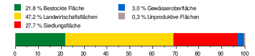
It consists of 21.8% wooded area , 47.2% agricultural area , 27.7% settlement area , 3.0% water area and 0.3% unproductive areas.
Area distribution
The mean height of the catchment area is 523 m above sea level. M. , the minimum height is 408 m above sea level. M. and the maximum height at 839 m above sea level. M.
Hydrology
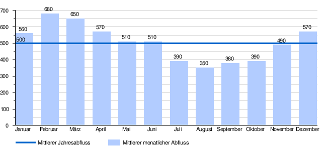
At the confluence of the Ron into the Reuss, its modeled mean flow rate (MQ) is 500 l / s. Her discharge regime type is pluvial inférieur and her discharge variability is 25.
Individual evidence
- ↑ a b c d Geoserver of the Swiss Federal Administration ( information )
- ↑ a b Topographical catchment areas of Swiss waters: Ron
- ↑ "Hidden behind the mean values" - the variability of the discharge regime , p. 7
- ↑ The discharge variability describes the extent of the fluctuations in the mean discharge of individual years around the long-term mean discharge value.