Rosovka
| Rosovka | ||
|
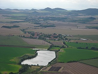
View from the rabbit castle to the nameless pond between Lkáň and Klapý |
||
| Data | ||
| location | Ústecký kraj , Czech Republic | |
| River system | Elbe | |
| Drain over | Eger → Elbe → North Sea | |
| source | at Solany 50 ° 27 ′ 0 ″ N , 13 ° 55 ′ 30 ″ E |
|
| muzzle | near Radovesice ( Radowesitz ) in the Eger coordinates: 50 ° 24 ′ 33 ″ N , 14 ° 4 ′ 42 ″ E 50 ° 24 ′ 33 ″ N , 14 ° 4 ′ 42 ″ E
|
|
| length | 18 km | |
| Catchment area | 59.5 km² | |
The Rosovka , also Klapský potok or Klapská Modla (German Kleiner Modelbach , Sollaner Bach or Klapskybach ) is a left tributary of the Ohře (German: Eger ) in the Czech Republic . The Rosovka flows in the Okres Litoměřice through the Bohemian Central Uplands .
geography
The Rosovka arises east of the village Solany at the southeastern foot of the Kvítel (354 m) from several source streams that merge in the Podhrázský rybník pond, whereby the western source stream previously bifurcated part of its water to the stream Žejdlík.
It then flows in a south-easterly direction through Lkáň and Klapý , north of Libochovice and south of Slatina pod Hazmburkem . East of Radovesice the Rosovka flows into the Ohře.
The 418 meter high Hazmburk (German Hasenburg ), one of the most striking mountains of the Bohemian Central Uplands , which is crowned by the ruins of the Gothic Hazmburk Castle , lies to the north. In the years 1882, 1898, 1900 and 1939 several debris flows into the Rosovka valley broke away on its slope .
In addition to the Podhrázský rybník, the Rosovka is dammed in two nameless ponds.
Tributaries
- Voračovka (l), below Lkáň
- Podsedický potok (l), southeast of Slatina pod Hazmburkem
Web links
- Description (the specified length of 69.7 km is obviously wrong; PDF; 1.3 MB)
