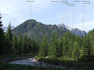
Roztocka Czuba
| Roztocka Czuba | ||
|---|---|---|
|
View from the Dolina Białki valley |
||
| height | 1425 m npm | |
| location | Poland , Lesser Poland | |
| Mountains | High Tatras , Carpathian Mountains | |
| Coordinates | 49 ° 13 '43 " N , 20 ° 5' 29" E | |
|
|
||
The Fünfseenkoppe ( Polish Roztocka Czuba ) is a mountain in the massif of the Miedziane Grań in the Polish High Tatras in the Lesser Poland Voivodeship with an altitude of 1425 m npm
Location and surroundings
Below the summit the valleys are Roztoka Marmot ( Świstówka Roztocká ) to the west, Fish Lake Valley to the west and Roztokatal in the north.
The Fünfseenkoppe lies between the mountain passes Fünfseesattel ( Roztockie Siodło ) and Zirbenjoch ( Limbowa Przełęcz ). It lies in the northeast ridge of the massif.
etymology
The name Roztocka Czuba can be translated as Roztoka hill and refers to the name of the Dolina Roztoki valley .
First ascent
The ascent to the Fünfseenkoppe is quite easy. It can therefore be assumed that shepherds, miners and poachers have been climbing it since the 17th century at the latest.
tourism
There is no marked hiking trail on the Fünfseenkoppe.
At the foot of the massif are the shelters Schronisko PTTK nad Morskim Okiem in the east and Schronisko PTTK w Dolinie Pięciu Stawów Polskich in the west. Not far from the summit is the Schronisko PTTK w Dolinie Roztoki refuge .
Web links
supporting documents
- Zofia Radwańska-Paryska, Witold Henryk Paryski, Wielka encyklopedia tatrzańska, Poronin, Wyd. Górskie, 2004, ISBN 83-7104-009-1 .
- Tatry Wysokie słowackie i polskie. Mapa turystyczna 1: 25.000, Warszawa, 2005/06, Polkart, ISBN 83-87873-26-8 .

